- La Sal Mountains
-
La Sal Mountains 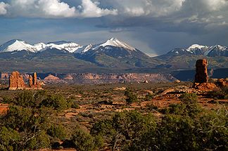
Die La Sal Mountains vom Arches-Nationalpark aus gesehen
Höchster Gipfel Mount Peale (3.877 m) Lage Utah (USA) Teil der Rocky Mountains 

Koordinaten 38° 26′ N, 109° 14′ W38.438611111111-109.229166666673877Koordinaten: 38° 26′ N, 109° 14′ W Die La Sal Mountains, auch La Sal Range, sind eine Gebirgskette im Osten des US-Bundesstaates Utah in den Countys San Juan und Grand. Die La Sal Mountains liegen im Manti-La Sal National Forest. Die höchste Erhebung der Gebirgskette ist der 3.877 m hohe Mount Peale.
Im Frühsommer des Jahres 1776 entdeckte der spanische Missionar Silvestre Vélez de Escalante am Horizont die aus der Wüste aufragenden weißen schneebedeckten Gipfel der La Sal Mountains. Da er sich nicht vorstellen konnte, in diesem heißen unwirtlichen Gebiet Schnee zu sehen, hielt er die weißen Kuppen für reines Salz und nannte den Gebirgszug Sierra de la Sal, also "die salzigen Berge". Im Jahr 1899 machte der deutsche Forscher Carl Purpus eine Expedition in die La Sal Mountains und erforschte die bis dahin noch weitgehend unbekannte Kakteenflora dieser Region.
Erhebungen
- Mount Peale (3.877 m)
- Mount Mellenthin (3.854 m)
- Mount Tukuhnikivatz (3.805 m)
- Mount Waas (3.758 m)
- Manns Peak (3.741 m)
- Mount Laurel (3.740 m)
- Mount Tomasaki (3.730 m)
- Pilot Mountain (3.719 m)
- Green Mountain (3.707 m)
- Little Tuk (3.672 m)
Kategorien:- Gebirge in den Vereinigten Staaten
- Gebirge in Nordamerika
- Geographie (Utah)
- Bergkette der Rocky Mountains


Wikimedia Foundation.