- Lake of the Woods County
-
Verwaltung US-Bundesstaat: Minnesota Verwaltungssitz: Baudette Adresse des
Verwaltungssitzes:County Courthouse
206 SE 8th Avenue
Baudette, MN 56623-0000Gründung: 28. November 1922 Gebildet aus: Beltrami County Vorwahl: 001 218 Demographie Einwohner: 4045 (2010) Bevölkerungsdichte: 1,2 Einwohner/km² Geographie Fläche gesamt: 4.597 km² Wasserfläche: 1.239 km² Karte 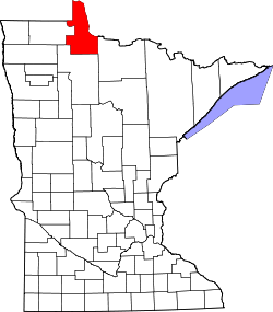
Website: www.co.lake-of-the-woods.mn.us Das Lake of the Woods County[1] ist ein County im US-amerikanischen Bundesstaat Minnesota. Bei der Volkszählung im Jahr 2010 hatte das County 4.045 Einwohner und eine Bevölkerungsdichte von 1,2 Einwohnern pro Quadratkilometer. Der Verwaltungssitz (County Seat) ist Baudette.
Inhaltsverzeichnis
Geografie
Das County liegt im äußersten Norden von Minnesota, grenzt an Kanada und hat eine Fläche von 4597 Quadratkilometern, wovon 1239 Quadratkilometer Wasserfläche sind. Zum County gehört der so genannte Northwest Angle, der einzige Teil der USA außerhalb von Alaska, der nördlich des 49. Breitengrades liegt.
Da Alaska keine Countys hat ist das Lake of the Woods County das nördlichste County der Vereinigten Staaten. Es grenzt an folgende Countys und Distrikte:
Provinz Manitoba
(Kanada)Kenora District
(Ontario, Kanada)Roseau County 
Rainy River District,
(Ontario, Kanada)
Beltrami County Koochiching County Geschichte
Das Lake of the Woods County wurde am 28. November 1922 aus Teilen des Beltrami County gebildet. Benannt wurde es nach dem Lake of the Woods, der die nördliche Grenze darstellt.
Demografische Daten
Historische Einwohnerzahlen Census Einwohner ± in % 1930 4194 — 1940 5975 40 % 1950 4955 -20 % 1960 4304 -10 % 1970 3987 -7 % 1980 3764 -6 % 1990 4076 8 % 2000 4522 10 % 2010 4045 -10 % 1900–1990[2] 2000[3] 2010[4] Nach der Volkszählung im Jahr 2000 lebten im Lake of the Woods County 4.522 Menschen in 1.903 Haushalten und 1.267 Familien. Die Bevölkerungsdichte betrug 1 Einwohner pro Quadratkilometer. Ethnisch betrachtet setzte sich die Bevölkerung zusammen aus 97,21 Prozent Weißen, 0,29 Prozent Afroamerikanern, 1,13 Prozent amerikanischen Ureinwohnern, 0,24 Prozent Asiaten und 0,11 Prozent aus anderen ethnischen Gruppen; 1,02 Prozent stammten von zwei oder mehr Ethnien ab. 0,64 Prozent der Bevölkerung waren spanischer oder lateinamerikanischer Abstammung, die verschiedenen der genannten Gruppen angehörten.
Von den 1.903 Haushalten hatten 29,2 Prozent Kinder unter 18 Jahren, die bei ihnen lebten. 57,4 Prozent davon waren verheiratete, zusammenlebende Paare. 5,3 Prozent waren alleinerziehende Mütter und 33,4 Prozent waren keine Familien. 29,7 Prozent waren Singlehaushalte und in 12,9 Prozent der Haushalte lebten alleinstehende Menschen im Alter von 65 Jahren oder darüber. Die Durchschnittshaushaltsgröße lag bei 2,35 Personen, die durchschnittliche Familiengröße bei 2,93 Personen.
24,7 Prozent der Bevölkerung waren unter 18 Jahre alt. 5,7 Prozent waren zwischen 18 und 24, 25,1 Prozent zwischen 25 und 44, 27,2 Prozent zwischen 45 und 64 und 17,2 Prozent waren älter als 65 Jahre. Das Durchschnittsalter betrug 42 Jahre. Auf 100 weibliche kamen statistisch 101 männliche Personen. Auf 100 Frauen im Alter von 18 Jahren oder darüber kamen 102,6 Männer.
Das jährliche Durchschnittseinkommen eines Haushalts betrug 32.861 USD und das Durchschnittseinkommen einer Familie betrug 38.936 USD. Männer hatten ein Durchschnittseinkommen von 30.469 USD, Frauen 24.813 USD. Das Pro - Kopf - Einkommen betrug 16.976 USD. 6,7 Prozent der Familien und 9,8 Prozent der Einwohner lebten unterhalb der Armutsgrenze.[5]
Städte und Gemeinden
- Baudette
- Roosevelt1
- Williams
1 - teilweise im Roseau County
Einzelnachweise
- ↑ GNIS-ID: 659483. Abgerufen am 22. Februar 2011 (englisch).
- ↑ Auszug aus Census.gov Abgerufen am 17. Februar 2011
- ↑ Auszug aus factfinder.census.gov Abgerufen am 18. Februar 2011
- ↑ United States Census 2010 Abgerufen am 1. August 2011
- ↑ Lake of the Woods County, Minnesota Datenblatt mit den Ergebnissen der Volkszählung im Jahre 2000 bei factfinder.census.gov
Weblinks
-
 Commons: Lake of the Woods County, Minnesota – Sammlung von Bildern, Videos und Audiodateien
 - Offizielle Webseite
- Lake of the Woods Tourism
- www.city-data.com - Lake of the Woods County

Liste der Countys in Minnesota
Aitkin | Anoka | Becker | Beltrami | Benton | Big Stone | Blue Earth | Brown | Carlton | Carver | Cass | Chippewa | Chisago | Clay | Clearwater | Cook | Cottonwood | Crow Wing | Dakota | Dodge | Douglas | Faribault | Fillmore | Freeborn | Goodhue | Grant | Hennepin | Houston | Hubbard | Isanti | Itasca | Jackson | Kanabec | Kandiyohi | Kittson | Koochiching | Lac qui Parle | Lake | Lake of the Woods | Le Sueur | Lincoln | Lyon | Mahnomen | Marshall | Martin | McLeod | Meeker | Mille Lacs | Morrison | Mower | Murray | Nicollet | Nobles | Norman | Olmsted | Otter Tail | Pennington | Pine | Pipestone | Polk | Pope | Ramsey | Red Lake | Redwood | Renville | Rice | Rock | Roseau | Scott | Sherburne | Sibley | St. Louis | Stearns | Steele | Stevens | Swift | Todd | Traverse | Wabasha | Wadena | Waseca | Washington | Watonwan | Wilkin | Winona | Wright | Yellow Medicine
Wikimedia Foundation.
Schlagen Sie auch in anderen Wörterbüchern nach:
Lake of the Woods County — Sp Miškų Ẽžero apýgarda Ap Lake of the Woods County L JAV (Minesota) … Pasaulio vietovardžiai. Internetinė duomenų bazė
Lake of the Woods County — Admin ASC 2 Code Orig. name Lake of the Woods County Country and Admin Code US.MN.077 US … World countries Adminstrative division ASC I-II
Lake of the Woods County, Minnesota — Infobox U.S. County county = Lake of the Woods County state = Minnesota founded year = 1923 [http://www.house.leg.state.mn.us/hinfo/govseries/No32.htm] founded date = January 1 seat wl = Baudette largest city wl = Baudette area total sq mi = 1775 … Wikipedia
Chilgren Township, Lake of the Woods County, Minnesota — Chilgren Township is a township in Lake of the Woods County, Minnesota, United States. The population was 179 at the 2000 census. Geography According to the United States Census Bureau, the township has a total area of 36.0 square miles… … Wikipedia
McDougald Township, Lake of the Woods County, Minnesota — McDougald Township is a township in Lake of the Woods County, Minnesota, United States. The population was 236 at the 2000 census. Geography According to the United States Census Bureau, the township has a total area of 35.3 square miles (91 … Wikipedia
Myhre Township, Lake of the Woods County, Minnesota — Myhre Township is a township in Lake of the Woods County, Minnesota, United States. The population was 213 at the 2000 census. Geography According to the United States Census Bureau, the township has a total area of 35.8 square miles… … Wikipedia
Spooner Township, Lake of the Woods County, Minnesota — Spooner Township is a township in Lake of the Woods County, Minnesota, United States. The population was 281 at the 2000 census. Spooner Township adjoined the Village of Spooner, which merged with Baudette in 1954. [ [http://www.co.lake of the… … Wikipedia
Lakewood Township, Lake of the Woods County, Minnesota — Lakewood Township is a township in Lake of the Woods County, Minnesota, United States. The population was 116 at the 2000 census. It borders the Lake of the Woods.GeographyAccording to the United States Census Bureau, the township has a total… … Wikipedia
Rulien Township, Lake of the Woods County, Minnesota — Rulien Township is a township in Lake of the Woods County, Minnesota. As of the 2000 census, the township had a total population of three. According to the United States Census Bureau, it is one of only nine places in the United States with a… … Wikipedia
Angle Township, Lake of the Woods County, Minnesota — Angle Township is a township in Lake of the Woods County, Minnesota, United States. The population was 152 at the 2000 census. At 49.22º north latitude, it is the northernmost township in Minnesota and the northernmost point in the contiguous 48… … Wikipedia
Lake of the Woods County


18+
© Academic, 2000-2024
- Kontaktieren Sie uns: Unterstützung, Werbung
Wörterbücher Export, schritte mit PHP, Joomla, Drupal, WordPress, MODx.