- Latady-Insel
-
Latady-Insel Infrarotaufnahme August 2009 (Terra-Satellit)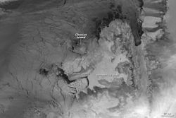
Gewässer Bellingshausensee (Südlicher Ozean) Geographische Lage 70° 45′ S, 74° 35′ W-70.75-74.583333333333Koordinaten: 70° 45′ S, 74° 35′ W 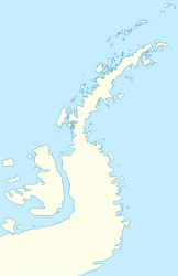

Länge 60 km Breite 40 km Fläche 3.300 km² Einwohner (unbewohnt) Die Latady-Insel (engl. Latady Island) ist eine von Eis bedeckte Insel in der Westantarktis. Sie liegt 72 km südlich der Charcot-Insel und westlich der Alexander-Insel, und bildet die südöstliche Begrenzung des Wilkins-Schelfeises. Die Insel ist etwa 60 km lang, 40 km breit und hat eine Fläche von 3,300 km². 1929 sah Sir Hubert Wilkins aus der Luft ein eisbedecktes Gebilde an dieser Stelle und beschrieb diese, erkannte aber weder, dass es sich um eine Insel handelt, noch kartografierte er sie separat.
Die Latady-Insel wurde aus der Luft während der Ronne Antarctic Research Expedition (RARE) in den Jahren 1947 und 1948 fotografiert und 1960 anhand dieser Fotos durch Derek John Hatherhill Searle vom Falkland Islands Dependencies Survey (FIDS) kartografiert. Die Latady-Insel wurde vom UK Antarctic Place-Names Committee (UK-APC) nach William R. Latady, einem Luftfotografen und Navigator des Fluges der Ronne Antarctic Research Expedition benannt.
Weblinks
- 'Webcam’ from Space Envisat Advanced Synthetic Aperture Radar (ASAR)
Kategorien:- Unbewohnte Insel
- Insel (Antarktika)
- Insel (Südlicher Ozean)


Wikimedia Foundation.