- Lingayen
-
Municipality of Lingayén Lage von Lingayen in der Provinz Pangasinán 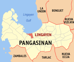
Basisdaten Bezirk: Ilocos-Region Provinz: Pangasinán Baranggays: 32 Distrikt: 2. Distrikt von Pangasinán PSGC: Einkommensklasse: 1. Einkommensklasse Haushalte: 16.467 Zensus 1. Mai 2000Einwohnerzahl: Expression-Fehler: Unerwarteter Operator: <Expression-Fehler: Unerwarteter Operator: <Expression-Fehler: Unerwarteter Operator: <Expression-Fehler: Unerwarteter Operator: <Expression-Fehler: Unerwarteter Operator: <Expression-Fehler: Unerwarteter Operator: < Zensus 1. August 2007Koordinaten: 16° 1′ N, 120° 14′ O16.016666666667120.23333333333Koordinaten: 16° 1′ N, 120° 14′ O Postleitzahl: 2401 Vorwahl: +63 75 Geographische Lage auf den Philippinen 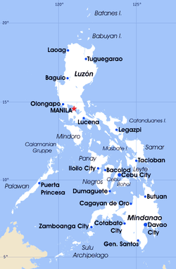

Lingayen Lingayén ist eine Stadtgemeinde in der philippinischen Provinz Pangasinán und der Verwaltungssitz der Provinz. Im Jahre 2000 zählte Lingayén 88.891 Einwohner und 16.467 Haushalte. Der Golf von Lingayén ist nach der Gemeinde, welche direkt an der Küste liegt, benannt. Die Stadtgemeinde ist auch der Geburtsort des ehemaligen philippinischen Präsidenten Fidel V. Ramos.
Lingayén ist aufgeteilt in folgende 32 Baranggays:
- Aliwekwek
- Baay
- Balangobong
- Balococ
- Bantayan
- Basing
- Capandanan
- Domalandan Center
- Domalandan East
- Domalandan West
- Dorongan
- Dulag
- Estanza
- Lasip
- Libsong East
- Libsong West
- Malawa
- Malimpuec
- Maniboc
- Matalava
- Naguelguel
- Namolan
- Pangapisan North
- Pangapisan Sur
- Poblacion
- Quibaol
- Rosario
- Sabangan
- Talogtog
- Tonton
- Tumbar
- Wawa
Städte und Stadtgemeinden in der Provinz PangasinánStädte: Alaminos | Dagupan | San Carlos City | Urdaneta
Stadtgemeinden: Agno | Aguilar | Alcala | Anda | Asingan | Balungao | Bani | Basista | Bautista | Bayambang | Binalonan | Binmaley | Bolinao | Bugallon | Burgos | Calasiao | Dasol | Infanta | Labrador | Laoac | Lingayén | Mabini | Malasiqui | Manaoag | Mangaldan | Mangatarem | Mapandan | Natividad | Pozzorubio | Rosales | San Fabian | San Jacinto | San Manuel | San Nicolas | San Quintin | Santa Barbara | Santa Maria | Santo Tomas | Sison | Sual | Tayug | Umingan | Urbiztondo | Villasis


Wikimedia Foundation.