Little Missouri River (North Dakota)
- Little Missouri River (North Dakota)
-
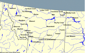
Der Little Missouri River ist ein 901 Kilometer langer Zufluss des Missouri River in den nördlichen Great Plains Nordamerikas.
Er entspringt im Nordosten des US-Bundesstaates Wyoming, etwa 35 Kilometer westlich vom Devils Tower im Crook County. Er fließt dann kontinuierlich nach Nordosten, schneidet eine Ecke Montanas und erreicht dann South Dakota, wo er die Badlands in nördlicher Richtung nach North Dakota durchfließt. Der Fluss durchquert das Little Missouri National Grassland, sowie die beiden Teile des Theodore-Roosevelt-Nationalparks, in dessen Nordteil er wieder nach Osten dreht und im Lake Sakakawea mündet. Dort bildet er einen 48 Kilometer langen Arm des Wasserspeichers, der Little Missouri Bay genannt wird und den Hauptkanal des Missouri etwa 40 Kilometer nördlich von Killdeer erreicht.
Siehe auch
Weblinks
Kategorien:
- Flusssystem Missouri River
- Fluss in Nordamerika
- Fluss in Montana
- Fluss in North Dakota
- Fluss in South Dakota
- Fluss in Wyoming
Wikimedia Foundation.
Schlagen Sie auch in anderen Wörterbüchern nach:
Little Missouri River (North Dakota) — The Little Missouri River is a tributary of the Missouri River, 560 mi (901 km) long, in the northern Great Plains of the United States.It rises in northeastern Wyoming, in western Crook County approximately twenty miles west of Devil s Tower. It … Wikipedia
Little Missouri River — ist der Name von zwei Flüssen in den Vereinigten Staaten: Little Missouri River (North Dakota) Little Missouri River (Arkansas) Diese Seite ist eine Begriffsklärung zur Unterscheidung mehrerer mit demselben Wor … Deutsch Wikipedia
Little Missouri River — The Little Missouri River can refer to two rivers in the United States:*The Little Missouri River (Arkansas) in Arkansas *The Little Missouri River (North Dakota) in Wyoming, South Dakota, and North Dakota … Wikipedia
Little Muddy Creek (North Dakota) — Little Muddy Creek is a tributary of the Missouri River, approximately 45 mi (70 km) long, in northwestern North Dakota in the United States.It rises in the prairie country of northern Williams County and flows west, then south, joining the… … Wikipedia
Little Missouri River — River, northwestern U.S. It rises in northeastern Wyoming and flows northeast across the southeastern corner of Montana and the northwestern corner of South Dakota. It continues north into North Dakota, turning east to empty into the Missouri… … Universalium
Little Missouri River — noun a river that rises in northeastern Wyoming and flows through Montana and South Dakota to join the Missouri River in North Dakota • Syn: ↑Little Missouri • Instance Hypernyms: ↑river • Part Holonyms: ↑Wyoming, ↑Equality State, ↑ … Useful english dictionary
North Dakota — noun a state of north central United States bordering on Canada • Syn: ↑Peace Garden State, ↑ND • Instance Hypernyms: ↑American state • Part Holonyms: ↑United States, ↑United States of America, ↑ … Useful english dictionary
Missouri River — Coordinates: 38°48′49″N 90°07′11″W / 38.81361°N 90.11972°W / 38.81361; 90.11972 … Wikipedia
North Dakota — North Dakotan. a state in the N central United States. 652,695; 70,665 sq. mi. (183,020 sq. km). Cap.: Bismarck. Abbr.: ND (for use with zip code), N. Dak. * * * State (pop., 2000: 642,200), U.S. Situated in the north central region, it is… … Universalium
Little Missouri — noun a river that rises in northeastern Wyoming and flows through Montana and South Dakota to join the Missouri River in North Dakota • Syn: ↑Little Missouri River • Instance Hypernyms: ↑river • Part Holonyms: ↑Wyoming, ↑Equality State, ↑ … Useful english dictionary