Mackinac Island

Mackinac Island

Vorlage:Infobox Insel/Wartung/Höhe fehlt

Mackinac Island
Grand Hotel auf Mackinac Island
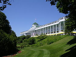
Gewässer Huronsee
Geographische Lage 45° 51′ 40″ N, 84° 37′ 50″ W45.861111111111-84.630555555556Koordinaten: 45° 51′ 40″ N, 84° 37′ 50″ W
Mackinac Island (Michigan)
Mackinac Island
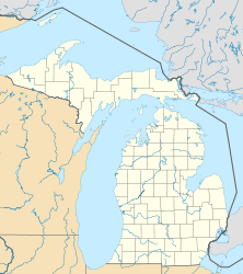
Fläche 9,779 km²
Topografische Karte
Topografische Karte

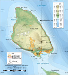
Mackinac Island [ˈmækɪˌnɔː] ist eine Insel im Huronsee östlich der Mackinacstraße (Mackinac County, Michigan). Ihre Fläche beträgt 9,779 km².

1875 entstand hier der zweite Nationalpark der Vereinigten Staaten, der Mackinac National Park. Bekannt ist die Insel für ihre viktorianischen Hotelbauten sowie durch das dort geltende Verbot von Automobilen. Geschichtlich bedeutsam ist Fort Mackinac.

Weblinks

 Commons: Mackinac Island, Michigan – Sammlung von Bildern, Videos und Audiodateien

Wikimedia Foundation.

Игры ⚽ Поможем написать курсовую

Schlagen Sie auch in anderen Wörterbüchern nach:

  • Mackinac Island — Mackinac Island, MI U.S. city in Michigan Population (2000): 523 Housing Units (2000): 565 Land area (2000): 4.365457 sq. miles (11.306482 sq. km) Water area (2000): 1.216806 sq. miles (3.151514 sq. km) Total area (2000): 5.582263 sq. miles… …   StarDict's U.S. Gazetteer Places

  • Mackinac Island, MI — U.S. city in Michigan Population (2000): 523 Housing Units (2000): 565 Land area (2000): 4.365457 sq. miles (11.306482 sq. km) Water area (2000): 1.216806 sq. miles (3.151514 sq. km) Total area (2000): 5.582263 sq. miles (14.457996 sq. km) FIPS… …   StarDict's U.S. Gazetteer Places

  • Mackinac Island — Infobox Islands name = Mackinac image caption = locator location map|Michigan|label=Mackinac Island|mark=Green pog.svg|lat dir=N|lat deg=45|lat min=51|lat sec=40|lon dir=W|lon deg=84|lon min=37|lon sec=50 map custom = yes native name =… …   Wikipedia

  • Mackinac Island — Île Mackinac « Mackinac Island » redirige ici. Pour les autres significations, voir Mackinac Island (Michigan). Île Mackinac Mackinac Island  …   Wikipédia en Français

  • Mackinac Island — Sp Mãkinako salà Ap Mackinac Island L Huronų ež., JAV (Mičigano v ja) …   Pasaulio vietovardžiai. Internetinė duomenų bazė

  • Mackinac Island (Míchigan) — Mackinac Island Ciudad de los Estados Unidos …   Wikipedia Español

  • Mackinac Island Public School — is the public school district serving Mackinac Island, Michigan. The school district is coterminous with the city and with the island. It is governed by a school board of 5 elected members. One school building, on Lake Shore Drive, is sufficient… …   Wikipedia

  • Mackinac Island Press — Mackinac Island Press, [http://www.mackinacislandpress.com] is a national publisher of children s books, where it jumped onto the national stage with Has Anyone Seen Christmas? The book was featured across the country by Barnes Noble and featured …   Wikipedia

  • Mackinac Island — Island in the Straits of Mackinac, southeastern Upper Peninsula of Michigan, U.S. It is 3 mi (5 km) long. It was an ancient Indian burial ground called Michilimackinac when the British built a fort there in 1780. After the U.S. took possession in …   Universalium

  • Mackinac Island State Park — Infobox protected area | name = Mackinac Island State Park iucn category = caption = locator x = locator y = location = Michigan, USA nearest city = Mackinac Island, Michigan lat degrees = 45 lat minutes = 52 lat direction = N long degrees = 84… …   Wikipedia

Share the article and excerpts

Direct link
Do a right-click on the link above
and select “Copy Link”