- Manukan
-
Municipality of Manukan Lage von Manukan in der Provinz Zamboanga del Norte 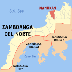
Basisdaten Bezirk: Zamboanga Peninsula Provinz: Zamboanga del Norte Barangays: 22 Distrikt: 2. Distrikt von Zamboanga del Norte PSGC: 097207000 Einkommensklasse: 3. Einkommensklasse Haushalte: 6010 Zensus 1. Mai 2000Einwohnerzahl: 33.129 Zensus 1. August 2007Koordinaten: 8° 32′ N, 123° 6′ O8.5333333333333123.1Koordinaten: 8° 32′ N, 123° 6′ O Postleitzahl: 7110 Bürgermeister: Eugene U. Caballero Offizielle Webpräsenz: Manukan Geographische Lage auf den Philippinen 

Manukan Manukan ist eine philippinische Stadtgemeinde in der Provinz Zamboanga del Norte. Nach dem Zensus vom 1. Mai 2000 hat sie 31.855 Einwohner in 6010 Haushalten.
Baranggays
Manukan ist politisch in 22 Baranggays unterteilt.
- Dipane
- Disakan
- Don Jose Aguirre
- East Poblacion
- Gupot
- Libuton
- Linay
- Lingatongan
- Lupasang
- Mate
- Meses
- Palaranan
- Pangandao
- Patagan
- Poblacion
- Punta Blanca
- Saluyong
- San Antonio
- Serongan
- Suisayan
- Upper Disakan
- Villaramos
Städte und Stadtgemeinden in der Provinz Zamboanga del NorteStädte: Dapitan City | Dipolog City
Stadtgemeinden: Bacungan | Baliguian | Godod | Gutalac | Jose Dalman | Kalawit | Katipunan | La Libertad | Labason | Liloy | Manukan | Mutia | Piñan | Polanco | Pres. Manuel A. Roxas | Rizal | Salug | Sergio Osmeña Sr. | Siayan | Sibuco | Sibutad | Sindangan | Siocon | Sirawai | Tampilisan
Wikimedia Foundation.
Schlagen Sie auch in anderen Wörterbüchern nach:
Manukan — es un municipio de Primera Clase de la provincia en Zamboanga del Norte, Filipinas. De acuerdo con el censo del 2000, tiene una población de 31,855 en 6,010 hogares. Manukan fue fundado el 16 de junio de 1951. Proviene el nombre de la térmio… … Wikipedia Español
Manukan — Original name in latin Manukan Name in other language State code PH Continent/City Asia/Manila longitude 8.53333 latitude 123.1 altitude 9999 Population 11523 Date 2010 08 14 … Cities with a population over 1000 database
Manukan Island Resort — (Кота Кинабалу,Малайзия) Категория отеля: 1 звездочный отель Адрес: Manukan Is … Каталог отелей
Manukan, Zamboanga del Norte — Municipality of Manukan Bayan ng Manukan Municipality Municipality of Manukan … Wikipedia
Pulau Manukan — A seaview of Mamutik, Sulug and Manukan … Wikipedia
Kota Kinabalu — View of the Kota Kinabalu city … Wikipedia
Tunku Abdul Rahman National Park — Infobox protected area | name = Tunku Abdul Rahman National Park iucn category = II caption = Police Bay locator x = locator y = location = Sabah, Malaysia nearest city = Kota Kinabalu lat degrees = lat minutes = lat seconds = lat direction =… … Wikipedia
INTI College Sabah — is an associate campus of INTI International University College. It is located in Kota Kinabalu, Sabah, Malaysia. It offers foundation, diploma and degree programmes in business, tourism and information technology. The current student population… … Wikipedia
PH-ZAN — Lage von Zamboanga del Norte Zamboanga del Norte ist eine Provinz, die sich auf der Insel Mindanao im Süden der Philippinen befindet. Sie nimmt den nordwestlichen und nördl … Deutsch Wikipedia
Dipolog — City of Dipolog Bagbenwa Dipuleg Lungsod ng Dipolog Ciudad de Dipolog Dakbayan sa Dipolog … Wikipedia
Manukan


18+
© Academic, 2000-2024
- Kontaktieren Sie uns: Unterstützung, Werbung
Wörterbücher Export, schritte mit PHP, Joomla, Drupal, WordPress, MODx.