- Marinette County
-
 Das Marinette County Courthouse in Marinette
Verwaltung US-Bundesstaat: Wisconsin Verwaltungssitz: Marinette Adresse des
Verwaltungssitzes:County Courthouse
1926 Hall Avenue
Marinette, WI 54143-1717Gründung: 1879 Gebildet aus: Oconto County Vorwahl: 001 715 Demographie Einwohner: 41.749 (2010) Bevölkerungsdichte: 11,5 Einwohner/km² Geographie Fläche gesamt: 4.015 km² Wasserfläche: 384 km² Karte 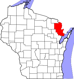
Website: www.marinettecounty.com Marinette County[1] ist ein County im Bundesstaat Wisconsin der Vereinigten Staaten von Amerika. Bei der Volkszählung im Jahr 2010 hatte das County 41.749 Einwohner und eine Bevölkerungsdichte von 11,5 Einwohnern pro Quadratkilometer. Der Verwaltungssitz (County Seat) ist Marinette.
Inhaltsverzeichnis
Geografie
Das County liegt im Nordosten von Wisconsin, grenzt im Norden an Michigan, im Südosten an den Michigansee und hat eine Fläche von 4015 Quadratkilometern, wovon 384 Quadratkilometer Wasserfläche sind. Es grenzt an folgende Countys:
Florence County Dickinson County
(Michigan)Menominee County
(Michigan)Forest County 
Oconto County Geschichte
Marinette County wurde 1879 aus Teilen des Oconto County gebildet. Benannt wurde es, ebenso wie die Bezirkshauptstadt nach Marguerite Chevallier einer frühen Besitzerin eines Handelsposten, auch Queen Marinette genannt.
Demografische Daten
Historische Einwohnerzahlen Census Einwohner ± in % 1900 30.822 — 1910 33.812 10 % 1920 34.361 2 % 1930 33.530 -2 % 1940 36.225 8 % 1950 35.748 -1 % 1960 34.660 -3 % 1970 35.810 3 % 1980 39.314 10 % 1990 40.548 3 % 2000 43.384 7 % 2010 41.749 -4 % 1900-1990[2] 2010[3]  Bevölkerungspyramide (2000) im Marinette County
Nach der Volkszählung im Jahr 2000 lebten im Marinette County 43.384 Menschen in 17.585 Haushalten. 11.834 Familien lebten im County. Die Bevölkerungsdichte betrug 12 Personen pro Quadratkilometer. Ethnisch betrachtet setzte sich die Bevölkerung zusammen aus 98,08 Prozent Weißen, 0,23 Prozent Afroamerikanern, 0,50 Prozent amerikanischen Ureinwohnern, 0,27 Prozent Asiaten, 0,02 Prozent Bewohnern aus dem pazifischen Inselraum und 0,21 Prozent aus anderen ethnischen Gruppen; 0,69 Prozent stammten von zwei oder mehr Ethnien ab. 0,75 Prozent der Bevölkerung waren spanischer oder lateinamerikanischer Abstammung, die verschiedenen der genannten Gruppen angehörten.
Von den 17.585 Haushalten hatten 28,8 Prozent Kinder unter 18 Jahren, die mit ihnen zusammen lebten. 56,4 Prozent davon waren verheiratete, zusammenlebende Paare, 7,4 Prozent waren allein erziehende Mütter. 32,7 Prozent waren keine Familien. 28,3 Prozent waren Singlehaushalte und in 13,3 Prozent lebten Menschen mit 65 Jahren oder älter. Die durchschnittliche Haushaltsgröße lag bei 2,38 und die durchschnittliche Familiengröße bei 2,92 Personen.
23,5 Prozent der Bevölkerung waren unter 18 Jahre alt, 8,1 Prozent zwischen 18 und 24, 25,9 Prozent zwischen 25 und 44, 25,0 Prozent zwischen 45 und 64, und 17,6 Prozent waren 65 Jahre oder älter. Das Durchschnittsalter betrug 40 Jahre. Auf 100 weibliche kamen statistisch 97,5 männliche Personen.[4]
Städte und Gemeinden
- Coleman
- Crivitz
- Marinette
- Niagara
- Peshtigo
- Pound
- Wausaukee
Einzelnachweise
- ↑ Marinette County im Geographic Names Information System des United States Geological Survey Abgerufen am 22. Februar 2011
- ↑ Auszug aus Census.gov Abgerufen am 28. Februar 2011
- ↑ United States Census 2010 Abgerufen am 10. April 2011
- ↑ Marinette County, Wisconsin Datenblatt mit den Ergebnissen der Volkszählung im Jahre 2000 bei factfinder.census.gov
Weblinks
-
 Commons: Marinette County, Wisconsin – Sammlung von Bildern, Videos und Audiodateien
 - Offizielle Webseite
- www.city-data.com

Liste der Countys in Wisconsin
Adams | Ashland | Barron | Bayfield | Brown | Buffalo | Burnett | Calumet | Chippewa | Clark | Columbia | Crawford | Dane | Dodge | Door | Douglas | Dunn | Eau Claire | Florence | Fond du Lac | Forest | Grant | Green | Green Lake | Iowa | Iron | Jackson | Jefferson | Juneau | Kenosha | Kewaunee | La Crosse | Lafayette | Langlade | Lincoln | Manitowoc | Marathon | Marinette | Marquette | Menominee | Milwaukee | Monroe | Oconto | Oneida | Outagamie | Ozaukee | Pepin | Pierce | Polk | Portage | Price | Racine | Richland | Rock | Rusk | Sauk | Sawyer | Shawano | Sheboygan | St. Croix | Taylor | Trempealeau | Vernon | Vilas | Walworth | Washburn | Washington | Waukesha | Waupaca | Waushara | Winnebago | Wood
Wikimedia Foundation.
Schlagen Sie auch in anderen Wörterbüchern nach:
Marinette County — Comté de Marinette Comté de Marinette (Marinette County) Administration Pays … Wikipédia en Français
Marinette County — Admin ASC 2 Code Orig. name Marinette County Country and Admin Code US.WI.075 US … World countries Adminstrative division ASC I-II
Marinette County, Wisconsin — Location in the state of Wisconsin … Wikipedia
National Register of Historic Places listings in Marinette County, Wisconsin — Buildings, sites, districts, and objects in Marinette County listed on the National Register of Historic Places See also: National Register of Historic Places listings in Wisconsin This National Park Service list is complete through NPS recent… … Wikipedia
USS Marinette County (LST-953) — The USS Marinette County (LST 953) was a sclass|LST 542|tank landing ship built for the United States Navy during World War II. Named after Marinette County, Wisconsin, she was the only U.S. Naval vessel to bear the name.Originally laid down as… … Wikipedia
Murphy Lake (Marinette County, Wisconsin) — Murphy Lake Location Marinette County, Wisconsin Coordinates 45°07′54″N 88°07′30″W … Wikipedia
Beaver, Marinette County, Wisconsin — Infobox Settlement official name = Beaver, Wisconsin settlement type = Town nickname = motto = imagesize = image caption = image mapsize = 250px map caption = Location of Beaver, Wisconsin mapsize1 = map caption1 = subdivision type = Country… … Wikipedia
Grover, Marinette County, Wisconsin — Infobox Settlement official name = Grover, Wisconsin settlement type = Town nickname = motto = imagesize = image caption = image mapsize = 250px map caption = Location of Grover, Wisconsin mapsize1 = map caption1 = subdivision type = Country… … Wikipedia
Lake, Marinette County, Wisconsin — Infobox Settlement official name = Lake, Wisconsin settlement type = Town nickname = motto = imagesize = image caption = image mapsize = 250px map caption = Location of Lake, Wisconsin mapsize1 = map caption1 = subdivision type = Country… … Wikipedia
Marinette, Wisconsin — City Location of Marinette, Wisconsin … Wikipedia
Marinette County


18+
© Academic, 2000-2024
- Kontaktieren Sie uns: Unterstützung, Werbung
Wörterbücher Export, schritte mit PHP, Joomla, Drupal, WordPress, MODx.