- Monroe County (Pennsylvania)
-
Verwaltung US-Bundesstaat: Pennsylvania Verwaltungssitz: Stroudsburg Gründung: 1. April 1836 Gebildet aus: Northampton County
Pike CountyVorwahl: 001 570 Demographie Einwohner: 164.722 (2007) Bevölkerungsdichte: 104,5 Einwohner/km² Geographie Fläche gesamt: 1.599 km² Wasserfläche: 23 km² Karte 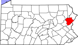
Website: www.co.monroe.pa.us Monroe County[1] ist ein County im Bundesstaat Pennsylvania der Vereinigten Staaten von Amerika. Im Jahr 2007 hatte das County laut offizieller Schätzung 164.722 Einwohner und eine Bevölkerungsdichte von 105 Einwohner pro Quadratkilometer. Der Verwaltungssitz (County Seat) ist Stroudsburg.
Inhaltsverzeichnis
Geschichte
Monroe County wurde am 1. April 1836 aus Northampton County und Pike County gebildet und nach US-Präsident James Monroe benannt.
Geografie
Das County hat eine Fläche von 1599 Quadratkilometern, wovon 23 Quadratkilometer Wasserfläche sind.
Städte und Ortschaften
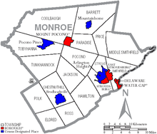 Karte des Monroe Countys
- Arlington Heights
- Barrett Township
- Brodheadsville
- Chestnuthill Township
- Coolbaugh Township
- Delaware Water Gap
- East Stroudsburg
- Eldred Township
- Hamilton Township
- Jackson Township
- Middle Smithfield Township
- Mount Pocono
- Mountainhome
- Paradise Township
- Pocono Pines
- Pocono Township
- Polk Township
- Price Township
- Ross Township
- Smithfield Township
- Stroud Township
- Stroudsburg
- Tobyhanna Township
- Tunkhannock Township
Historische Einwohnerzahlen Census Einwohner ± in % 1900 21.161 — 1910 22.941 8 % 1920 24.295 6 % 1930 28.286 20 % 1940 29.802 5 % 1950 33.773 10 % 1960 39.567 20 % 1970 45.422 10 % 1980 69.409 50 % 1990 95.709 40 % 2000 138.687 40 % 1900–1990[2] 2000[3]
Einzelnachweise
- ↑ Monroe County im Geographic Names Information System des United States Geological Survey. Abgerufen am 22. Februar 2011
- ↑ Auszug aus Census.gov. Abgerufen am 28. Februar 2011
- ↑ Auszug aus factfinder.census.gov Abgerufen am 28. Februar 2011

Liste der Countys in Pennsylvania
Adams | Allegheny | Armstrong | Beaver | Bedford | Berks | Blair | Bradford | Bucks | Butler | Cambria | Cameron | Carbon | Centre | Chester | Clarion | Clearfield | Clinton | Columbia | Crawford | Cumberland | Dauphin | Delaware | Elk | Erie | Fayette | Forest | Franklin | Fulton | Greene | Huntingdon | Indiana | Jefferson | Juniata | Lackawanna | Lancaster | Lawrence | Lebanon | Lehigh | Luzerne | Lycoming | McKean | Mercer | Mifflin | Monroe | Montgomery | Montour | Northampton | Northumberland | Perry | Philadelphia | Pike | Potter | Schuylkill | Snyder | Somerset | Sullivan | Susquehanna | Tioga | Union | Venango | Warren | Washington | Wayne | Westmoreland | Wyoming | York
Wikimedia Foundation.
Schlagen Sie auch in anderen Wörterbüchern nach:
Monroe County, Pennsylvania — Location in the state of Pennsylvania … Wikipedia
National Register of Historic Places listings in Monroe County, Pennsylvania — Location of Monroe County in Pennsylvania This is a list of the National Register of Historic Places listings in Monroe County, Pennsylvania. This is intended to be a complete list of the properties and districts on the National Register of… … Wikipedia
Middle Smithfield Township, Monroe County, Pennsylvania — For other Pennsylvania townships with similar names, see Smithfield Township, Pennsylvania. Coordinates: 41°05′00″N 74°59′35″W / 41.0833333°N 74.9930 … Wikipedia
Chestnuthill Township, Monroe County, Pennsylvania — Coordinates: 40°56′00″N 75°21′59″W / 40.9333333°N 75.36639°W / 40.9333333; 75.36639 … Wikipedia
Coolbaugh Township, Monroe County, Pennsylvania — Coordinates: 41°12′00″N 75°31′59″W / 41.2°N 75.53306°W / 41.2; 75.53306 … Wikipedia
Jackson Township, Monroe County, Pennsylvania — Geobox Township name = Jackson Township native name = other name = other name1 = category = image size = image caption = flag size = symbol = symbol size = country = United States state = Pennsylvania region = Monroe region type = County district … Wikipedia
Eldred Township, Monroe County, Pennsylvania — Geobox Township name = Eldred Township native name = other name = other name1 = category = image size = image caption = flag size = symbol = symbol size = country = United States state = Pennsylvania region = Monroe region type = County district … Wikipedia
Hamilton Township, Monroe County, Pennsylvania — Geobox Township name = Hamilton Township native name = other name = other name1 = category = image size = image caption = A Hamilton Township vista flag size = symbol = symbol size = country = United States state = Pennsylvania region = Monroe… … Wikipedia
Paradise Township, Monroe County, Pennsylvania — Geobox Township name = Paradise Township native name = other name = other name1 = category = image size = image caption = Industrial remains are surrounded by forest in Paradise Township flag size = symbol = symbol size = country = United States… … Wikipedia
Polk Township, Monroe County, Pennsylvania — Geobox Township name = Polk Township native name = other name = other name1 = category = image size = image caption = flag size = symbol = symbol size = country = United States state = Pennsylvania region = Monroe region type = County district =… … Wikipedia
Monroe County (Pennsylvania)


18+
© Academic, 2000-2024
- Kontaktieren Sie uns: Unterstützung, Werbung
Wörterbücher Export, schritte mit PHP, Joomla, Drupal, WordPress, MODx.