Arizona State Highway 264
Schlagen Sie auch in anderen Wörterbüchern nach:
Arizona State Route 264 — Infobox road marker state=AZ highway name= name notes= type=state route=264 alternate name= maint= length mi=154.35 length round=2 length ref=cite web |url=http://tpd.az.gov/data/reports/2006SHSLog.pdf |title=2006 ADOT Highway Log |author=Arizona … Wikipedia
Arizona State Route 264 — Karte … Deutsch Wikipedia
Arizona State Highway 87 — Karte … Deutsch Wikipedia
Arizona State Route 87 — Infobox road marker state=AZ highway name= name notes= type=state route=87 alternate name= maint= length mi=272.66 length round=2 length ref=cite web |url=http://tpd.az.gov/data/reports/2006SHSLog.pdf |title=2006 ADOT Highway Log |author=Arizona… … Wikipedia
Arizona State Route 87 — Karte … Deutsch Wikipedia
New Mexico State Route 264 — Basisdaten Gesamtlänge: 15.945 mi/ 26 km Eröffnung: … Deutsch Wikipedia
Arizona State Route 266 — Infobox road marker state=AZ highway name= name notes= type=state route=266 alternate name= maint= length mi=19.18 length round=2 length ref=cite web |url=http://tpd.az.gov/data/reports/2006SHSLog.pdf |title=2006 ADOT Highway Log |author=Arizona… … Wikipedia
Arizona State Route 261 — Infobox road marker state=AZ highway name= name notes= type=state route=261 alternate name= maint= length mi=17.92 length round=2 length ref=cite web |url=http://tpd.az.gov/data/reports/2006SHSLog.pdf |title=2006 ADOT Highway Log |author=Arizona… … Wikipedia
State highways deleted by the Utah State Legislature in 1969 — A number of minor state highways in the U.S. state of Utah were deleted by the State Legislature in 1969.tate Route 53State Route 53 connected SR 8 (now US 6/US 191) at Wellington with SR 6 (now US 40) west of Myton via Nine Mile Canyon Road. The … Wikipedia
Liste der Highways in Arizona — Dies ist eine Aufstellung von State Routes, U.S. Highways und Interstates im US Bundesstaat Arizona, nach Nummern. Inhaltsverzeichnis 1 State Routes 1.1 Gegenwärtige Strecken 1.2 Geplante Strecken 1.3 Außer Die … Deutsch Wikipedia
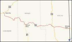
 US 160 in Tuba City
 NM 264 bei Window Rock
