- Mount Spurr
-
Mount Spurr 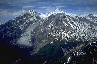
Mount Spurr
Höhe 3.374 m Lage Alaska, USA Gebirge Tordrillo Mountains, Alaskakette Geographische Lage 61° 17′ 59″ N, 152° 15′ 5″ W61.299722222222-152.251388888893374Koordinaten: 61° 17′ 59″ N, 152° 15′ 5″ W 

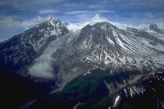
Typ Schichtvulkan Gestein Andesit Letzte Eruption 1992 Der Mount Spurr ist ein 3.374 m hoher Schichtvulkan in den zur Alaskakette gehörenden Tordrillo Mountains in Alaska. Er ist in der Caldera eines älteren Vulkans entstanden, die einen Durchmesser von bis zu 6 km und eine Höhe von 3.000 m hat.
Der Mount Spurr hat neben dem Hauptgipfel mit dem Crater Peak einen zweiten Eruptionsschlot, der sich in einem Bruch der alten Caldera gebildet hat. Während der Hauptgipfel seit über 5.000 Jahren inaktiv ist, gab es am Crater Peak zuletzt 1953 und 1992 Ausbrüche, die zu Ascheregen bis ins 130 km östlich liegende Anchorage führten.
Der Fußbereich des Mount Spurr ist von pyroklastischen Ablagerungen mit Eruptivgängen und vulkanischen Lagergängen, die Flanken von andesitischen Lavaströmen bedeckt.
Benannt ist der Berg nach Josiah Edward Spurr, einem Geologen des United States Geological Survey, der 1898 eine Expedition in die Gegend leitete. Die Nähe des Mount Spurr zu transpazifischen Flugrouten birgt potentielle Gefahren für den Flugverkehr.
-

Ausbruch des Crater Peak im August 1992
-

Der Crater Peak mit dem Hauptgipfel im Hintergrund
Weblinks
 Commons: Mount Spurr – Sammlung von Bildern, Videos und Audiodateien
- Mount Spurr im Global Volcanism Program der Smithsonian Institution (englisch)
- Mount Spurr / Alaska Volcano Observatory
- Mount Spurr Webcam
Kategorien:- Dreitausender
- Berg in Nordamerika
- Berg in Alaska
- Schichtvulkan
-


Wikimedia Foundation.