- Narrandera Shire
-
Shire of Narrandera 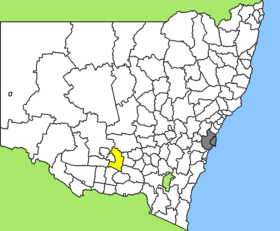
Lage des Narrandera Shire in New South WalesGliederung Staat:  Australien
Bundesstaat:  New South Wales
Verwaltungssitz: Narrandera Daten und Zahlen Fläche: 4.117 km² Einwohner: 6.012 (2006) [1] Bevölkerungsdichte: 1,5 Einwohner je km² -34.5534.55Koordinaten: 34° 33′ S, 34° 33′ ONarrandera Shire ist ein lokales Verwaltungsgebiet (LGA) im australischen Bundesstaat New South Wales. Das Gebiet ist 4.117 km² groß und hat etwa 6.000 Einwohner.
Narrandera liegt im Süden des Staates in der Region um den Murrumbidgee River etwa 550 km südwestlich der Metropole Sydney und 340 km nordwestlich der australischen Hauptstadt Canberra. Das Gebiet umfasst 38 Ortsteile und Ortschaften: Bells Estate, Berembed, Berembed Weir, Birrego, Brewarrena, Brobenah, Buckingbong, Bundidjarie, Colinroobie, Corobmilla, Dixonville, Faithfull, Garoolgan, Gillenbah, Jacksons Water Hole, Kywong, Landervale, Merribee, Midgeon, Lake Midgeon, Mount Crystal, Narrandera, Paynters Crossing, Paynters Siding, Pine Hill, Pine Hills, Poison Waterhole, Sandigo, Yanco Weir und Teile von Ardlethan, Barellan, Binya, Boree Creek, Galore, Grong Grong, Kamarah, Matong und Moombooldool. Der Sitz des Shire Councils befindet sich in der Stadt Narrandera im Süden der LGA, wo etwa 4.000 Einwohner leben.
Verwaltung
Der Narrandera Shire Council hat neun Mitglieder, die von den Bewohnern der LGA gewählt werden. Narrandera ist nicht in Bezirke untergliedert. Aus dem Kreis der Councillor rekrutiert sich auch der Mayor (Bürgermeister) des Councils.
Weblinks
Einzelnachweise
- ↑ Australian Bureau of Statistics (25. Oktober 2007): Narrandera (A) (Local Government Area) (Englisch). 2006 Census QuickStats. Abgerufen am 6. April 2010.
Kategorie:- Local Government Area in New South Wales

Wikimedia Foundation.