Nootamaa

Nootamaa

Vorlage:Infobox Insel/Wartung/Bild fehltVorlage:Infobox Insel/Wartung/Höhe fehlt

Nootamaa
Gewässer Ostsee
Inselgruppe Moonsund-Inseln
Geographische Lage 58° 19′ 22″ N, 21° 45′ 59″ O58.32277777777821.766388888889Koordinaten: 58° 19′ 22″ N, 21° 45′ 59″ O
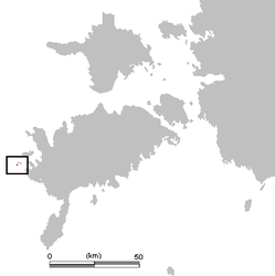
Lage von Nootamaa
Fläche 5,8 Hektardep1
Einwohner (unbewohnt)

Nootamaa ist eine estnische Ostsee-Insel. Sie stellt den westlichsten Punkt Estlands dar.

Lage und Beschreibung

Nootamaa liegt etwa einen Kilometer südwestlich der Insel Loonalaid. Die Fläche der Insel beträgt 5,8 Hektar.

Nootamaa gehört verwaltungsmäßig zur Gemeinde Lümanda im Kreis Saare.

Die unbewohnte Insel ist Teil des Nationalparks Vilsandi. Fauna und Flora stehen unter Naturschutz. Auf der Insel finden sich 132 verschiedene Pflanzenarten.[1] Daneben ist die Insel als Brutkolonie für Vögel bekannt.

Weblinks

Einzelnachweise

  1. http://www.estlandia.de/tourismus/wandern/vilsandi-nationalpark.html

Wikimedia Foundation.

Игры ⚽ Нужен реферат?

Schlagen Sie auch in anderen Wörterbüchern nach:

  • Nootamaa — is a small island in the Baltic Sea belonging to the country of Estonia. It marks the westernmost part of Estonia s territorial boundary. Its coordinates are 58°19′12″N 21°46′50″E / 58.32°N 21.78056°E / 58.32; 21.78056 …   Wikipedia

  • Nootamaa — es una isla báltica de Estonia. Pertence administrativamente al municipio rural de Lümanda, en el condado de Saare. Las coordenadas de Nootamaa son: 58°19′″N 21°46′″E / <span class= geo dec geo title= Fotos, mapas y otros datos de Expresión… …   Wikipedia Español

  • Saaremaa — This article is about the island. For the village in Võru County, see Saaremaa, Võru County. Saaremaa …   Wikipedia

  • Hiiumaa — Tahkuna peninsula is the most northern part of Hiiumaa Geography …   Wikipedia

  • List of islands of Estonia — This is a list of islands of Estonia. There are 1521 islands. This is not a complete list. CompactTOC10|sections= A B C D E F G H I J K L M N O P Q R S Š Z Ž T U V W Õ Ä Ö Ü X YAAbruka Adralaid Aegna (Wulf) Ahelaid Aherahu (Atla) Aherahu Ahessäär …   Wikipedia

  • Vormsi — Estonia s fourth largest island, Vormsi (German: Worms, Swedish: Ormsö), is located between Hiiumaa and the mainland with a total area of 93 square kilometers. It is part of a rural municipality Vormsi Parish. From mainland, Vormsi is separated… …   Wikipedia

  • Muhu — (German: Mohn/Moon; in Estonian also called Muhumaa), is an island in the Baltic Sea. With an area of 198 km² it is the third largest island belonging to Estonia, after Saaremaa and Hiiumaa. Together with neighbouring smaller islands of… …   Wikipedia

  • Naissaar — from the air Viimsi parish Naissaar …   Wikipedia

  • Osmussaar — Limestone cliff on the east coast of Osmussaar Geography Location …   Wikipedia

  • Extreme points of Estonia — This is a list of the extreme points of Estonia: the points that are farther north, south, east or west than any other location. Estonia* North : Vaindloo (coord|59|49|17|N|26|21|31|E|type:landmark region:EE|name=Vaindloo (North)) * South :… …   Wikipedia

Share the article and excerpts

Direct link
Do a right-click on the link above
and select “Copy Link”