- Ordnance Island
-
Ordnance Island (Ordinance Island) Ordnance Island (Bildmitte) in der Bucht Bermuda Harbour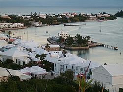
Gewässer Atlantischer Ozean Inselgruppe Bermuda Geographische Lage 32° 22′ 49″ N, 64° 40′ 35″ W32.380277777778-64.6763888888896Koordinaten: 32° 22′ 49″ N, 64° 40′ 35″ W 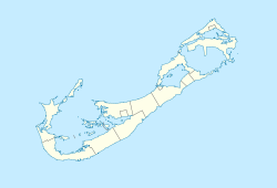

Länge 160 m Breite 39 m Fläche 0,006 km² Höchste Erhebung 6 m Einwohner (unbewohnt) Lage von Ordnance Island (rot eingekreist)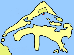
innerhalb der BermudasOrdnance Island, manchmal auch Ordinance Island genannt, ist eine sehr kleine Insel im Nordosten von Bermuda. Die Insel liegt im Saint George’s Harbour, keine vierzig Meter vor der Südküste (in Höhe des Marktplatzes King’s Square) der bermudischen Stadt Saint George’s, mit welcher sie heute über eine kleine Brücke verbunden ist.
Die etwa 160 Meter lange und 39 Meter breite Insel ist künstlich: Winzige Eilande in der Bucht (Duck Stool Island, Frazer’s Island und Gallows Island) wurden durch Sandaufschüttungen verbunden.
Ordnance Island diente einst als Lagerstätte für militärische Ausrüstungen, später als U-Boot-Basis der US-Marine und heute vornehmlich nur noch als Anleger für Kreuzfahrtschiffe.
Die Insel zählt zum Gebiet der (kreisfreien) Stadt Saint George’s, und gehört daher – wie diese – nicht zum Saint George’s Parish.
Siehe auch
Weblinks
- Inseln im St. George's Parish (engl.)
Kategorien:- Unbewohnte Insel
- Insel (Bermuda)
- Insel (Nordamerika)
- Insel (Atlantischer Ozean)
- Insel der Bermudas
- Künstliche Insel


Wikimedia Foundation.