Painted Stone Portage

Painted Stone Portage
Lage in Manitoba
Painted Stone Portage (Manitoba)
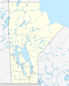
Painted Stone Portage
Staat: Kanada
Provinz: Manitoba
Koordinaten: 54° 24′ N, 96° 42′ W54.39239-96.70331212Koordinaten: 54° 24′ N, 96° 42′ W
Höhe: 212 m

Painted Stone Portage ist ein Portage an der Wasserscheide zwischen den Entwässerungsbecken des Nelson und Hayes Rivers in der kanadischen Provinz Manitoba. Sie wurde bis zum 19. Jahrhundert von der Hudson’s Bay Company für Fellhandelsexpeditionen von York Factory aus in das kanadische Inland benutzt. Mit nur etwa 10 Metern zwischen dem Hayes und dem Echimamish River ist sie wahrscheinlich die kürzeste Portage zwischen zwei Entwässerungsbecken überhaupt.


Wikimedia Foundation.

Игры ⚽ Нужно сделать НИР?

Schlagen Sie auch in anderen Wörterbüchern nach:

  • Hayes River — Infobox River river name = Hayes River caption = origin = mouth =Hudson Bay basin countries = Canada length =483 km (300 mi) elevation = mouth elevation = discharge =590 m³/s (772 yd³/s) watershed = convert|108000|km2|sqmi| 3|abbr=onThe Hayes… …   Wikipedia

  • Hayes River — Der Hayes River mit York Factory, kurz vor der Mündung in die Hudson Bay um 1925Vorlage:Infobox Flus …   Deutsch Wikipedia

  • Niagara Frontier Transportation Authority — NFTA redirects here. For Nondeterministic Finite Tree Automaton, see Tree automaton. For the North American trade agreement, see NAFTA. Niagara Frontier Transportation Authority Slogan Serving Buffalo Niagara Founded 1967 …   Wikipedia

  • Akron, Ohio — Akron redirects here. For other uses, see Akron (disambiguation). City of Akron   City   …   Wikipedia

  • List of National Monuments of the United States — The United States has 101 protected areas known as national monuments. The President of the United States can establish a national monument by executive order, and the United States Congress can by legislation. The Antiquities Act of 1906… …   Wikipedia

  • Ojibwe people — This article is about the native North American people. For other uses of Ojibwe , Ojibway , or Ojibwa , see Ojibway (disambiguation). Chippewa redirects here. For other uses, see Chippewa (disambiguation). Ojibwe Symbol of the Anishinaabe people …   Wikipedia

  • North Shore (Lake Superior) — Split Rock Lighthouse is on North Shore of Lake Superior. This is part of a Minnesota State Park and is open for visitors …   Wikipedia

  • Timeline of Russian inventions and technology records — The Hall of Space Technology in the Tsiolkovsky State Museum of the History of Cosmonautics, Kaluga, Russia. The exhibition includes the models and replicas of the following Russian inventions: the first satellite, Sputnik 1 (a ball under the… …   Wikipedia

  • National Network — A map of the National Network. The National Network (or National Truck Network) is a network of approved state highways and interstates for commercial truck drivers in the United States. The Surface Transportation Assistance Act of 1982… …   Wikipedia

  • List of National Historic Sites of Canada in Ontario — Map of all coordinates from Google Map of all coordinates from Bing Export all coordinates as KML …   Wikipedia

Share the article and excerpts

Direct link
Do a right-click on the link above
and select “Copy Link”