- Panukulan
-
Municipality of Panukulan Lage von Panukulan in der Provinz Quezon 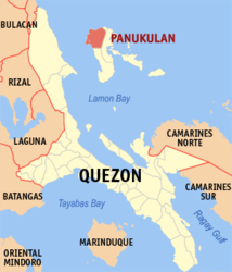
Basisdaten Bezirk: CALABARZON Provinz: Quezon Barangays: 12 Distrikt: 1. Distrikt von Quezon PSGC: 045631000 Einkommensklasse: 5. Einkommensklasse Haushalte: 2164 Zensus 1. Mai 2000Einwohnerzahl: 11.968 Zensus 1. August 2007Bevölkerungsdichte: 49 Einwohner je km² Fläche: 244,3 km² Koordinaten: 14° 33′ N, 121° 30′ O14.55121.5Koordinaten: 14° 33′ N, 121° 30′ O Postleitzahl: 4337 Offizielle Webpräsenz: www.panukulan.gov.ph Geographische Lage auf den Philippinen 

Panukulan Panukulan ist eine philippinische Stadtgemeinde in der Provinz Quezon. Nach dem Zensus vom 1. Mai 2000 hat sie 11.311 Einwohner in 2164 Haushalten.
Baranggays
Panukulan ist politisch in zwölf Baranggays unterteilt.
- Balungay
- Bato
- Bonbon
- Calasumanga
- Kinalagti
- Libo
- Lipata
- Matangkap
- Milawid
- Pagitan
- Pandan
- San Juan (Pob.)
Städte und Stadtgemeinden in der Provinz QuezonStädte: Lucena City | Tayabas City
Stadtgemeinden: Agdangan | Alabat | Atimonan | Buenavista | Burdeos | Calauag | Candelaria | Catanauan | Dolores | General Luna | General Nakar | Guinayangan | Gumaca | Infanta | Jomalig | Lopez | Lucban | Macalelon | Mauban | Mulanay | Padre Burgos | Pagbilao | Panukulan | Patnanungan | Perez | Pitogo | Plaridel | Polillo | Quezon | Real | Sampaloc | San Andres | San Antonio | San Francisco | San Narciso | Sariaya | Tagkawayan | Tiaong | Unisan
Wikimedia Foundation.
Schlagen Sie auch in anderen Wörterbüchern nach:
Panukulan — Original name in latin Panukulan Name in other language Panukulan State code PH Continent/City Asia/Manila longitude 14.93371 latitude 121.81685 altitude 2 Population 2836 Date 2012 06 05 … Cities with a population over 1000 database
Panukulan, Quezon — Infobox Philippine municipality infoboxtitle = Municipality of Panukulan sealfile = region = CALABARZON (Region IV) province = Quezon founded = June 21, 1959 pop2007 = 11,968 popden2007 = 49 areakm2 = 244.3 coordinates = Lat: 14.55° N, Long:… … Wikipedia
Polillo Island — Infobox Islands name = Polillo image caption = locator native name = native name link = location = Philippine islands coordinates=coord|14|50|N|121|57|E|region:PH type:isle archipelago = Philippine archipelago total islands = major islands = area … Wikipedia
Quezon — Infobox Philippine province name = Quezon sealfile = Ph seal quezon.png region = CALABARZON (Region IV A) capital = Lucena City founded = March 2, 1901 (as Tayabas) pop2000 = 1,679,030 pop2000rank = 12th largest popden2000 = 193 popden2000rank =… … Wikipedia
Padre Burgos, Quezon — Padre Burgos Municipality Seal … Wikipedia
Polillo, Quezon — Infobox Philippine municipality infoboxtitle = Pollilo sealfile = region = CALABARZON (Region IV) province = Quezon founded = pop2007 = 27,912 popden2007 = 97 areakm2 = 286.5 coordinates = barangays = 20 class = 2nd class; partially urban… … Wikipedia
Dolores, Quezon — Dolores Municipality Map of Quezon showing the location of Dolores … Wikipedia
Mauban, Quezon — Mauban Municipality A view of town proper from Rizal Hill Monument in the center of Mauban … Wikipedia
Mulanay, Quezon — Mulanay Municipality Map of Quezon showing the location of Mulanay … Wikipedia
Plaridel, Quezon — Plaridel Municipality Map of Quezon showing the location of Plaridel … Wikipedia
Panukulan


18+
© Academic, 2000-2024
- Kontaktieren Sie uns: Unterstützung, Werbung
Wörterbücher Export, schritte mit PHP, Joomla, Drupal, WordPress, MODx.