- Pukamaru
-
Takume NASA-Bild von Takume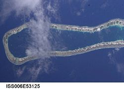
Gewässer Pazifischer Ozean Archipel Anzahl der Inseln --- Hauptinsel --- Landfläche 5 km² Lagunenfläche 43,5 km² Einwohner 93 (2002) Geographische Lage 15° 48′ S, 142° 12′ W-15.8-142.2Koordinaten: 15° 48′ S, 142° 12′ W 
 Lage von Takume (rot, 3)
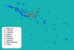
Takume, auch Pukamaru genannt, ist ein Atoll des Tuamotu-Archipels in Französisch-Polynesien, 120 km westlich von Fangatau gelegen. Takume gehört zur Gemeinde Makemo, welche aus den Atollen Makemo, Haraiki, Marutea Nord, Katiu, Tuanake, Hiti, Tepoto Sud, Raroia, Takume, Taenga und Nihiru besteht.Takume ist 24 km lang und teilweise 5 km breit. Die Lagune hat keinen schiffbaren Zugang zum Meer und weist eine Fläche von 42,4 km² auf. Takume besteht aus unzähligen Motus, die insgesamt eine Landfläche von 5 km² aufweisen. Das Atoll hat 93 Bewohner (Stand: 2002), wichtigster Ort der Inseln ist Ohomo.
Die beiden Atolle Takume und Raroia heißen bei den Paumotu ursprünglich Napaite, „Die Zwillinge“ (ite = zwei).
Das Atoll wurde 1820 von Fabian Gottlieb von Bellingshausen entdeckt. 1996 wurde ein Flughafen auf der Insel eingeweiht.
Weblinks

Ahe | Ahunui | Akiaki | Amanu | Anaa | Anuanuraro | Anuanurunga | Apataki | Aratika | Arutua | Faaite | Fakahina | Fakarava | Fangatau | Fangataufa | Gambier | Hao | Haraiki | Héréhérétué | Hikueru | Hiti | Katiu | Kauehi | Kaukura | Makatea | Makemo | Manihi | Manuhangi | Maria Est | Marokau | Marutea Nord | Marutea Sud | Mataiva | Matureivavao | Morane | Motutunga | Mururoa | Napuka | Nengonengo | Niau | Nihiru | Nukutavake | Nukutepipi | Paraoa | Pinaki | Puka-Puka | Puka Rua | Rangiroa | Raraka | Raroia | Ravahere | Reao | Reitoru | Rekareka | Taenga | Tahanea | Taiaro | Takapoto | Takaroa | Takume | Tatakoto | Tauere | Tekokota | Tematangi | Temoe | Tenararo | Tenarunga | Tepoto Nord | Tepoto Sud | Tikehau | Tikei | Toau | Tuanake | Tureia | Vahanga | Vahitahi | Vairaatea | Vanavana


Wikimedia Foundation.