Queanbeyan City

Queanbeyan City
City of Queanbeyan
Australia-Map-NSW-LGA-Queanbeyan.png
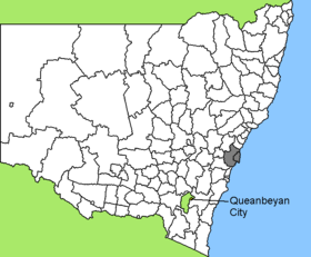
Lage von Queanbeyan City in New South Wales
Gliederung
Staat: Australien Australien
Bundesstaat: Flag of New South Wales.svg New South Wales
Verwaltungssitz: Queanbeyan
Daten und Zahlen
Fläche: 172 km²
Einwohner: 35.972 (2006) [1]
Bevölkerungsdichte: 209 Einwohner je km²
-35.35149.23333333333

Die City of Queanbeyan ist ein lokales Verwaltungsgebiet (LGA) im australischen Bundesstaat New South Wales. Das Gebiet ist 172 km² groß und hat etwa 36.000 Einwohner.

Queanbeyan grenzt westlich direkt an das Australian Capital Territory um die australische Hauptstadt Canberra. Das Gebiet umfasst 21 Ortsteile und Ortschaften: Burbong, Crestwood, De Salis, Dodsworth, Enfirona, Fernleigh Park, Gale, Greenleigh, Jerrabomberra, Karabar, Langdene, Larmer, Letchworth, Queanbeyan, Queanbeyan East, Ridgeway, Tralee, Yarrow un Teile von Carwoola, Googong und Royalla. Der Sitz des City Councils befindet sich im Stadtteil Queanbeyan.

Verwaltung

Der Queanbeyan City Council hat zehn Mitglieder. Neun Councillor und der Ratsvorsitzende und Mayor (Bürgermeister) werden direnkt von den Bewohnern der LGA gewählt. Queanbeyan ist nicht in Bezirke untergliedert.

Weblinks

Einzelnachweise

  1. Australian Bureau of Statistics (25. Oktober 2007): Queanbeyan (C) (Local Government Area) (Englisch). 2006 Census QuickStats. Abgerufen am 6. April 2010.

Wikimedia Foundation.

Игры ⚽ Нужно решить контрольную?

Schlagen Sie auch in anderen Wörterbüchern nach:

  • Queanbeyan City SC — Football club infobox clubname = Queanbeyan City nickname = fullname = Queanbeyan City Soccer Club founded = ?? ground = Riverside Stadium, Queanbeyan capacity = n/a chairman = league = ACT Premier League season = 2007 position = pattern b1=… …   Wikipedia

  • City of Queanbeyan — New South Wales Queanbeyan welcome sign Population: 4 …   Wikipedia

  • Queanbeyan — Luftaufnahme von Queanbeyan Staat …   Deutsch Wikipedia

  • Queanbeyan, New South Wales — Infobox Australian Place | type = city name = Queanbeyan state = nsw caption = Queanbeyan photographed from the air. The Ridgeway is in the right foreground, Jerrabobmerra in the top left. pop = 36,331 (2004) poprank = 37th density = 210 est =… …   Wikipedia

  • Queanbeyan East, New South Wales — Infobox Australian Place| type = town name = Queanbeyan East state = nsw caption = postcode = 2620 lga = Queanbeyan City Council stategov = Monaro fedgov = Eden Monaro est = pop = East Queanbeyan is one of Queanbeyan s newly proclaimed suburbs,… …   Wikipedia

  • Queanbeyan River — The Queanbeyan River joins the Molonglo River at Oaks Estate just within the Australian Capital Territory. The headwaters of the Queanbeyan River are approximately 70 kilometres east southeast of Queanbeyan near the village of Jerangle. The major …   Wikipedia

  • Queanbeyan High School — is a New South Wales Government School situated in a large service centre just beyond the limits of the Australian Capital Territory. Queanbeyan is a city of 28,000 people located on the Queanbeyan River 291 km south west of Sydney via Tarago and …   Wikipedia

  • City of Blue Mountains — New South Wales The Three Sisters are a top attraction of the city …   Wikipedia

  • City, Australian Capital Territory — City Canberra, Australian Capital Territory Population: 723 (2006 census) …   Wikipedia

  • City of Shoalhaven — New South Wales Location in NSW Population: 95,000(2009) …   Wikipedia

Share the article and excerpts

Direct link
Do a right-click on the link above
and select “Copy Link”