San Antonio Heights

San Antonio Heights
San Antonio Heights
San Bernardino County California Incorporated and Unincorporated areas San Antonio Heights Highlighted.svg
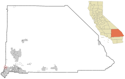
Lage im San Bernardino County
Basisdaten
Staat: Vereinigte Staaten
Bundesstaat: Kalifornien
County:

San Bernardino County

Koordinaten: 34° 9′ N, 117° 40′ W34.153055555556-117.66138888889641Koordinaten: 34° 9′ N, 117° 40′ W
Zeitzone: Pacific Standard Time (UTC−8)
Einwohner: 3122 (Stand: 2000)
Bevölkerungsdichte: 867,2 Einwohner je km²
Fläche: 3,7 km² (ca. 1 mi²)
davon 3,6 km² (ca. 1 mi²) Land
Höhe: 641 m
Postleitzahl: 91786
Vorwahl: +1 909
FIPS: 06-64462
GNIS-ID: 1661373

San Antonio Heights ist ein Census-designated place im San Bernardino County im US-Bundesstaat Kalifornien. San Antonio Heights hat 3122 Einwohner auf einer Fläche von 3,7 km². Die Bevölkerungsdichte liegt bei 861 Einwohner/km². Das Dorf liegt nördlich von Upland und westlich von Rancho Cucamonga. Es liegt an der Grenze zum Los Angeles County und an der Grenze zu den National Forests San Bernardino National Forest und Angeles National Forest. Nahe dem Dorf liegt auch der Claremont Hills Wilderness Park.

Von 1888 bis 1924 verband eine anfänglich mit Maultieren betriebene Straßenbahn den Ort mit den Gemeinden Upland und Ontario.


Wikimedia Foundation.

Игры ⚽ Поможем написать курсовую

Schlagen Sie auch in anderen Wörterbüchern nach:

  • San Antonio Heights — San Antonio Heights, CA U.S. Census Designated Place in California Population (2000): 3122 Housing Units (2000): 1121 Land area (2000): 1.400787 sq. miles (3.628022 sq. km) Water area (2000): 0.020669 sq. miles (0.053533 sq. km) Total area (2000) …   StarDict's U.S. Gazetteer Places

  • San Antonio Heights, CA — U.S. Census Designated Place in California Population (2000): 3122 Housing Units (2000): 1121 Land area (2000): 1.400787 sq. miles (3.628022 sq. km) Water area (2000): 0.020669 sq. miles (0.053533 sq. km) Total area (2000): 1.421456 sq. miles… …   StarDict's U.S. Gazetteer Places

  • San Antonio Heights — Original name in latin San Antonio Heights Name in other language State code US Continent/City America/Los Angeles longitude 34.15556 latitude 117.65644 altitude 648 Population 3371 Date 2011 05 14 …   Cities with a population over 1000 database

  • San Antonio Heights, California — Infobox Settlement official name = San Antonio Heights, California settlement type = CDP imagesize = image caption = image imagesize = image caption = image mapsize = 250x200px map caption = Location in San Bernardino County and the state of… …   Wikipedia

  • San Antonio — San Antonian. /san an toh nee oh / a city in S Texas: site of the Alamo. 785,410. * * * City (pop., 2000: 1,144,646), south central Texas, U.S. It is situated at the headwaters of the San Antonio River. Founded in 1718 by the Spanish as a mission …   Universalium

  • San Antonio Independent School District — is a school district based in Downtown San Antonio, Texas (USA).[1] San Antonio ISD is one of 15 school districts serving San Antonio. San Antonio ISD serves the downtown and inner city areas of San Antonio. San Antonio ISD also serves a small… …   Wikipedia

  • San Antonio, Oakland, California — Coordinates: 37°48′3.24″N 122°14′26.71″W / 37.8009°N 122.2407528°W / 37.8009; 122.2407528 …   Wikipedia

  • San Antonio — This article is about the U.S. city. For other uses, see San Antonio (disambiguation). City of San Antonio   City   …   Wikipedia

  • San Antonio Independent School District v. Rodriguez — SCOTUSCase Litigants=San Antonio Independent School District v. Rodriguez ArgueDate=October 12 ArgueYear=1972 DecideDate=March 21 DecideYear=1973 FullName=San Antonio Independent School District, et al. v. Demetrio P. Rodriguez, et al. USVol=411… …   Wikipedia

  • San Antonio, Texas — Infobox Settlement official name = City of San Antonio nickname = Alamo City, River City image map caption = Location in the state of Texas mapsize1 = 250px subdivision type = County subdivision name = Bexar leader title = Mayor leader name =… …   Wikipedia

Share the article and excerpts

Direct link
Do a right-click on the link above
and select “Copy Link”