- Santa Ana (Pampanga)
-
Municipality of Santa Ana Lage von Santa Ana in der Provinz Pampanga 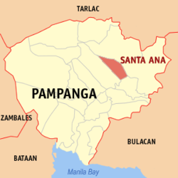
Basisdaten Bezirk: Central Luzon Provinz: Pampanga Barangays: 14 Distrikt: 3. Distrikt von Pampanga PSGC: 035419000 Einkommensklasse: 4. Einkommensklasse Haushalte: 7402 Zensus 1. Mai 2000Einwohnerzahl: 49.756 Zensus 1. August 2007Koordinaten: 15° 6′ N, 120° 46′ O15.094120.768Koordinaten: 15° 6′ N, 120° 46′ O Postleitzahl: 2022 Offizielle Webpräsenz: Santa Ana Geographische Lage auf den Philippinen 

Santa Ana Santa Ana ist eine philippinische Stadtgemeinde in der Provinz Pampanga. Nach dem Zensus vom 1. Mai 2000 hat sie 42.990 Einwohner in 7402 Haushalten.
Baranggays
Santa Ana ist politisch in 14 Baranggays unterteilt.
- San Agustin
- San Bartolome
- San Isidro
- San Joaquin (Pob.)
- San Jose
- San Juan
- San Nicolas
- San Pablo
- San Pedro
- San Roque
- Santa Lucia
- Santa Maria
- Santiago
- Santo Rosario
Städte und Stadtgemeinden in der Provinz PampangaStädte: Angeles City | San Fernando City
Stadtgemeinden: Apalit | Arayat | Bacolor | Candaba | Floridablanca | Guagua | Lubao | Mabalacat | Macabebe | Magalang | Masantol | Mexico | Minalin | Porac | San Luis | San Simon | Santa Ana | Santa Rita | Santo Tomas | Sasmuan
Wikimedia Foundation.
Schlagen Sie auch in anderen Wörterbüchern nach:
Santa Ana, Pampanga — Santa Ana is a 4th class municipality in the province of Pampanga, Philippines. According to the 2000 census, it has a population of 42,990 people in 7,402 households.BarangaysSanta Ana is politically subdivided into 14 barangays. Rich in… … Wikipedia
Santa Ana — (spanisch und portugiesisch für „Heilige Anna“) bezeichnet: in Argentinien Santa Ana (Misiones), einen Ort in der Provinz Misiones Santa Ana (Jujuy), einen Ort in der Provinz Jujuy Santa Ana (Santa Fe), eine Stadt in der Provinz Santa Fee Santa… … Deutsch Wikipedia
Santa Ana — or Santa Anna may refer to: People*Saint Anne, mother of the Virgin Mary *Santa Anna (Comanche war chief) (c. 1798 1849), Native American tribal leader *Antonio López de Santa Anna (1794 1876), Mexican general and PresidentPlacesNorth… … Wikipedia
Santa Rita (Pampanga) — Municipality of Santa Rita Lage von Santa Rita in der Provinz Pampanga Basisdaten Bezirk … Deutsch Wikipedia
Pampanga province — Pampanga Pampanga Localisation de la province de Pampanga (en rouge) dans les Philippines. Administration Pays … Wikipédia en Français
Pampanga — Provinz Pampanga Basisdaten Bezirk: Central Luzon … Deutsch Wikipedia
Pampanga — Provincia de la Pampanga Provincia de Filipinas Bandera de Pampanga Bandera … Wikipedia Español
Pampanga — 15° 04′ 00″ N 120° 40′ 00″ E / 15.06666667, 120.66666667 … Wikipédia en Français
San Luis, Pampanga — San Luis is a 4th class municipality in the province of Pampanga, Philippines. According to the 2000 census, it has a population of 41,554 people in 7,321 households.BarangaysSan Luis is politically subdivided into 17 barangays. * San Agustin *… … Wikipedia
San Fernando, Pampanga — For the city in La Union, see San Fernando City, La Union. For other uses, see San Fernando. City of San Fernando Lakanbalen ning San Fernando Lungsod ng San Fernando Regional Center … Wikipedia
Santa Ana (Pampanga)


18+
© Academic, 2000-2024
- Kontaktieren Sie uns: Unterstützung, Werbung
Wörterbücher Export, schritte mit PHP, Joomla, Drupal, WordPress, MODx.