- Singou
-
Singou 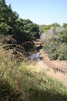
Der Singou an der Grenze zwischen dem Réserve partielle du Pama und dem Nationalpark Arly
Daten Lage Burkina Faso Flusssystem Volta Abfluss über Pendjari-Oti → Volta → Golf von Guinea Quelle in Burkina Faso Mündung in den Pendjari 11.1386111111111.0536111111111Koordinaten: 11° 8′ 19″ N, 1° 3′ 13″ O
11° 8′ 19″ N, 1° 3′ 13″ O11.1386111111111.0536111111111Der Singou ist ein Nebenfluss des Pendjari im südöstlichen Burkina Faso. Er entspringt im Réserve totale du Singou und bildet später die Grenze zwischen dem Réserve partielle de Pama und dem Nationalpark Arly.
Kategorien:- Flusssystem Volta
- Fluss in Afrika
- Fluss in Burkina Faso

Wikimedia Foundation.