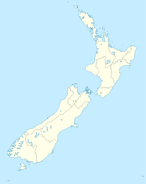
Te Karaka (Gisborne)

Te Karaka (Gisborne)
Te Karaka
Te Karaka (Neuseeland)
Te Karaka
Koordinaten 38° 38′ S, 177° 52′ O-38.636111111111177.86641666667Koordinaten: 38° 38′ S, 177° 52′ O
Einwohner 543 (2006)
Region Gisborne
Distrikt Gisborne

Te Karaka ist eine kleine Siedlung im Inland der Region Gisborne im Nordosten der der Nordinsel Neuseelands. Sie liegt im Tal des Waipaoa River nahe Puha, wo er sich mit dem Waihora River vereinigt. Te Karaka liegt am State Highway 2 und ist die größte Siedlung zwischen der Stadt Gisborne and Opotiki in the Region Bay of Plenty.

Beim Zensus 2006 hatte der Ort eine Bevölkerung von 543 ständigen Einwohnern.[1]

Quellen

  1. Statistics NZ profile

Wikimedia Foundation.

Игры ⚽ Нужно решить контрольную?

Schlagen Sie auch in anderen Wörterbüchern nach:

  • Te Karaka — Te Karake ist der māorische Name für Cape Campbell, in der Region Marlborough in Neuseeland des Magazins der Ngāi Tahu, einem Māoristamm auf der Südinsel Neuseelands, siehe Te Karake (Magazin) zweier Orte in Neuseeland: einen Ort in der Region… …   Deutsch Wikipedia

  • Moutohora Branch — [v · d · …   Wikipedia

  • Waipaoa River — Waipaoa RiverVorlage:Infobox Fluss/GKZ fehlt Lage Region Gisborne, Nordinsel, NeuseelandVorlage:Infobox Fluss/FLUSSSYSTEM fehlt Vorlage:Infobox Fluss/ABFLUSSWEG fehlt Quelle Raukumara RangeVorlage:Infobox Fluss/QUELLKOORDI …   Deutsch Wikipedia

  • Liste des lacs de Nouvelle-Zélande — Lac Wakatipu de Queenstown. Il y a 3 820 lacs en Nouvelle Zélande d une surface supérieure à un hectare. Ces derniers sont de types et d origines variés. Un grand nombre des lacs du centre de l Île du Nord résultent d un cratère volcanique tandis …   Wikipédia en Français

  • Northern Districts Knights — Infobox cricket team county=Northern Districts oneday=Northern Districts Knights coach=flagicon|England Andy Moles captain=flagicon|New Zealand James Marshall founded=1955 ground=Seddon Park capacity=10,000 fcdebutvs=Auckland fcdebutyr=1955… …   Wikipedia

  • New Zealand State Highway 2 — State Highway 2 Route information Maintained by …   Wikipedia

  • Ormond (Neuseeland) — p1 Ormond …   Deutsch Wikipedia

  • New Zealand State Highway 2 — Straßenschild des SH 2 Verlauf des SH 2 Der State Highway …   Deutsch Wikipedia

  • Waipatiki Beach — is a tiny village in Hastings District, Hawke s Bay, New Zealand. It is situated in a little valley at the end of a road that branches off the main road from Napier to Gisborne (SH 2) and that finally, after 11 km, leads to a small sandy beach;… …   Wikipedia

  • Cyclone Bola — This article is about the cyclone in 1988; for the deadly cyclone in 1970 that struck Bangladesh, see 1970 Bhola cyclone Tropical Cyclone Bola Category 4 cyclone (Australian scale) Category 3 cyclone (SSHS) Satel …   Wikipedia

Share the article and excerpts

Direct link
Do a right-click on the link above
and select “Copy Link”