- Temora Shire
-
Shire of Temora 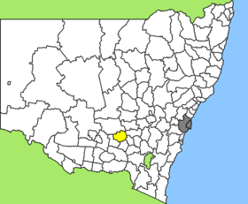
Lage des Temora Shire in New South WalesGliederung Staat:  Australien
Bundesstaat:  New South Wales
Verwaltungssitz: Temora Daten und Zahlen Fläche: 2.802 km² Einwohner: 5.853 (2006) [1] Bevölkerungsdichte: 2,1 Einwohner je km² -34.45147.53333333333Koordinaten: 34° 27′ S, 147° 32′ OTemora Shire ist ein lokales Verwaltungsgebiet (LGA) im australischen Bundesstaat New South Wales. Das Gebiet ist 2.802 km² groß und hat etwa 6.000 Einwohner.
Temora liegt in der Region um den Murrumbidgee River in der Südhälfte des Staates etwa 420 km westlich der Metropole Sydney und 210 km nordwestlich der australischen Hauptstadt Canberra. Das Gebiet umfasst 25 Ortsteile und Ortschaften: Bagdad, Bectric, Chellington, Clear Hills, Combaning, Combaning South, Dinga Dinga, Gidginbung, Narraburra, Pucawan, Quandary, Reefton, Sebastopol, Springdale, Tara, Temora, Trungley, Trungley Hall, Wallundry und Teile von Ariah Park, Coolamon, Grogan, Mimosa, Mirrool und Young. Der Sitz des Shire Councils befindet sich in der Stadt Temora im Zentrum der LGA, wo etwa 4.000 Einwohner leben.
Verwaltung
Der Temora Shire Council hat elf Mitglieder, die von den Bewohnern der LGA gewählt werden. Temora ist nicht in Bezirke untergliedert. Aus dem Kreis der Councillor rekrutiert sich auch der Mayor (Bürgermeister) des Councils.
Weblinks
Einzelnachweise
- ↑ Australian Bureau of Statistics (25. Oktober 2007): Temora (A) (Local Government Area) (Englisch). 2006 Census QuickStats. Abgerufen am 6. April 2010.
Kategorie:- Local Government Area in New South Wales

Wikimedia Foundation.