Tenaya Lake

Tenaya Lake
Tenaya Lake
Der Tenaya Lake von der Tioga Road gesehen Umgeben von Granitfelsen
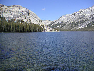
Geographische Lage Yosemite-Nationalpark, Kalifornien, USA
Zuflüsse Tenaya Creek
Abfluss Tenaya Creek → Merced River
Daten
Koordinaten 37° 49′ 50″ N, 119° 27′ 29″ W37.830555555556-119.458055555562484Koordinaten: 37° 49′ 50″ N, 119° 27′ 29″ W
Tenaya Lake (Kalifornien)
Tenaya Lake
Höhe über Meeresspiegel 2.484 m

Der Tenaya Lake ist ein See im Yosemite-Nationalpark im US-Bundesstaat Kalifornien. Er liegt zwischen dem Yosemite Valley und der Tuolumne-Wiese. Der See wurde durch den Tuolumne-Gletscher gebildet. Ausflüsse des Sees ist der Tenaya Creek, der durch den Tenaya Canyon im Yosemite Valley fließt. Der See liegt auf einer Höhe von 2484 m über dem Meeresspiegel. Der See wurde nach Tenaya benannt, dem Häuptling der bei benachbarten Stämmen als Yosemite bekannten Ahwahnee (Ahwahneechee).

Weblinks

 Commons: Tenaya Lake – Sammlung von Bildern, Videos und Audiodateien
Der Tenaya Lake von einem Felsen aus gesehen

Wikimedia Foundation.

Игры ⚽ Нужна курсовая?

Schlagen Sie auch in anderen Wörterbüchern nach:

  • Tenaya Lake — Infobox lake lake name = Tenaya Lake image lake = Tenaya lake 3.jpeg caption lake = Tenaya Lake as seen from a hill northwest of the lake image bathymetry = caption bathymetry = location = California coords =… …   Wikipedia

  • Tenaya Canyon — is a dramatic and dangerous canyon in Yosemite National Park, California, USA, that runs from the outlet of Tenaya Lake 10 miles down to Yosemite Valley, carrying water in Tenaya Creek through a series of spectacular cascades and pools and thence …   Wikipedia

  • Chief Tenaya — (died 1853) was a Native American chief of the Yosemite Valley people in California. Contents 1 Background 2 Leadership 3 Death 4 Legacy …   Wikipedia

  • Lago Tenaya — Vista del lago Tenaya. País …   Wikipedia Español

  • Mirror Lake (California) — Mirror Lake Mirror Lake, March 2010 Location Yosemite National Park, Mariposa County, California, USA …   Wikipedia

  • Ostrander Lake — For the Lake in Michigan s Upper Peninsula see: Ostrander Lake (Michigan) Ostrander Lake August 2005 Location Yosemite National Park, Mariposa County, Califor …   Wikipedia

  • Pine Mountain Lake, California — The entrance to the private gated community of Pine Mountain Lake lies eight tenths of a mile to the north and east of Groveland, and convert|26|mi|km|0 to the west gate of Yosemite National Park. The main gate is located on Ferretti Road, which… …   Wikipedia

  • Merced River — Coordinates: 37°20′57″N 120°58′32″W / 37.34917°N 120.97556°W / 37.34917; 120.97556 …   Wikipedia

  • Yosemite Valley — (pronEng|joʊˈsɛməti yoh SEM it ee ) is a world famous scenic location in the Sierra Nevada mountains of California. It is the centerpiece of Yosemite National Park, attracting visitors from all parts of the globe.The Valley is the point of entry… …   Wikipedia

  • History of the Yosemite area — [ Galen Clark was the first guardian of Yosemite Valley and the Mariposa Grove.] The known history of the Yosemite area started with Ahwahnechee and Paiute peoples who inhabited the central Sierra Nevada region of California that now includes… …   Wikipedia

Share the article and excerpts

Direct link
Do a right-click on the link above
and select “Copy Link”