Three Hummock Island

Three Hummock Island

Vorlage:Infobox Insel/Wartung/Bild fehlt

Three Hummock Island
Gewässer Tasmansee
Geographische Lage 40° 26′ 0″ S, 144° 55′ 0″ O-40.433333333333144.91666666667237Koordinaten: 40° 26′ 0″ S, 144° 55′ 0″ O
Three Hummock Island (Tasmanien)
Three Hummock Island
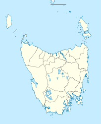
Fläche 70 km²
Höchste Erhebung 237 m
Bass Strait islands.png

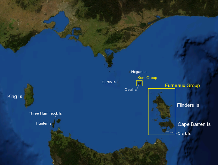
Three Hummock Island (deutsch „Drei-Hügel-Insel“) ist eine etwa 70 km² große Insel im westlichen Teil der Bass Strait zwischen Victoria und Tasmanien. Sie liegt nordöstlich von Hunter Island nahe der Nordwestküste von Tasmanien und ist am höchsten Punkt 237 m hoch.

Bereits lange bevor die Europäer die Insel entdeckten, jagten die Aborigines im Sommer auf der Insel. Sie mussten dazu die 5 km offene See von Hunter Island schwimmend überwinden.

Für die Europäer wurde die Insel 1798 von Matthew Flinders und seinem Schiffsarzt George Bass entdeckt. Flinders gab der Insel ihren Namen.

Im Jahre 1978 wurde ein großer Teil der Insel zum Naturschutzgebiet. Sie kann von Tasmanien aus in ca. 35 min Flugzeit mit Kleinflugzeugen erreicht werden.

Quellen


Wikimedia Foundation.

Игры ⚽ Нужно решить контрольную?

Schlagen Sie auch in anderen Wörterbüchern nach:

  • Three Hummock Island — is an island with an area of 70 km2 and a high point 237 m above sea level, in Bass Strait, south eastern Australia. It is part of Tasmania’s Hunter Island Group which lies between north west Tasmania and King Island. The island is named after… …   Wikipedia

  • Hummock Island — Note: There are several other Hummock Island s in the Falkland Islands Infobox Falkland island MapCaption= latitude= longitude= coordinates= island group= english name= Hummock Island spanish name= meaning of name= area= area rank= highest… …   Wikipedia

  • Hunter Island (Tasmanien) — Vorlage:Infobox Insel/Wartung/Bild fehltVorlage:Infobox Insel/Wartung/Fläche fehltVorlage:Infobox Insel/Wartung/Höhe fehlt Hunter Island Gewässer Tasmansee Geographische Lage …   Deutsch Wikipedia

  • Hunter Island (Tasmania) — Hunter Island is an island in the Bass Strait between Victoria and Tasmania in south eastern Australia.The island is run as a cattle property and has a homestead on the island. A privatley owned barge is used for transport to Smithton on the… …   Wikipedia

  • Bears Island (Tasmania) — Bears Island is a small island with an area of 0.34 ha, lying off the north west tip of Three Hummock Island in Bass Strait, south eastern Australia. It is part of Tasmania’s Hunter Island Group which lies between north west Tasmania and King… …   Wikipedia

  • Rabbit Island, Falkland Islands — Infobox Falkland island MapCaption= latitude= longitude= coordinates= island group= english name= Rabbit Island spanish name= meaning of name= area= area rank= highest elevation= Population= population rank= main settlement= references=Rabbit… …   Wikipedia

  • Masthead Island — IUCN Category II (National Park) …   Wikipedia

  • Moon Island (Massachusetts) — Moon Island is situated in Quincy Bay, in the middle of Boston Harbor, Massachusetts. All of the land on the island is owned by the City of Boston but the island is under the jurisdiction of Quincy, Massachusetts.[citation needed] It is also part …   Wikipedia

  • Три-Хаммок — Three Hummock Island Координаты: Координаты …   Википедия

  • Protected areas of Tasmania — Tasmania is the smallest state in Australia, and has a high amount of protected areas. Contents 1 Conservation areas 2 Forest reserves 3 Game reserves 4 Historic sites …   Wikipedia

Share the article and excerpts

Direct link
Do a right-click on the link above
and select “Copy Link”