Torrance County (New Mexico)
- Torrance County (New Mexico)
-
Torrance County ist eine County in New Mexico. 2000 lebten hier 16.911 Menschen. County-Sitz ist Estancia.
Geographie
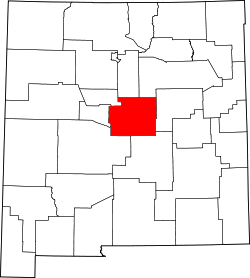
Torrance County hat eine Fläche von 8.666 km², 8.663 km² sind Land und 3 km² (0,03 %) sind Wasser. Die County ist genau in der Mitte New Mexicos.
Nachbar-Countys
Torrance County grenzt an folgende andere Countys:
Städte und Gemeinden
- Encino (New Mexico)
- Estancia (New Mexico)
- Monzano
- Moriarty (New Mexico)
- Mountainair
- Tajique
- Torreon
- Willard (New Mexico)
34.64-105.857Koordinaten: 34° 38′ N, 105° 51′ W
Wikimedia Foundation.
Schlagen Sie auch in anderen Wörterbüchern nach:
Torrance County, New Mexico — Infobox U.S. County county = Torrance County state = New Mexico map size = 200 founded = March 16, 1903 seat = Estancia | largest city = Moriarty area total sq mi =3346 area water sq mi =1 area percentage = 0.03% census yr = 2000 pop = 16911… … Wikipedia
Torreon, Torrance County, New Mexico — Infobox Settlement official name = Torreon, New Mexico settlement type = CDP nickname = motto = imagesize = image caption = image imagesize = image caption = image mapsize = 250px map caption = Location of Torreon in Torrance County, New Mexico… … Wikipedia
Bernalillo County (New Mexico) — Verwaltung US Bundesstaat: New Mexico Verwaltungssitz: Albuquerque Adresse des Verwaltungssitzes: Gründung … Deutsch Wikipedia
Bernalillo County, New Mexico — Infobox U.S. County county = Bernalillo County state = New Mexico map size = 200 founded = 1852 seat = Albuquerque | area total sq mi =1169 area land sq mi =1166 area water sq mi =3 area percentage = 0.22% census yr = 2000 pop = 556678 density… … Wikipedia
Socorro County, New Mexico — Infobox U.S. County county = Socorro County state = New Mexico map size = 200 founded = 1 July 1850 seat = Socorro | largest city = Socorro area total sq mi =6649 area water sq mi =2 area percentage = 0.03% census yr = 2000 pop = 18078 density… … Wikipedia
Lincoln County, New Mexico — Infobox U.S. County county = Lincoln County state = New Mexico map size = 200 founded = 1869 seat = Carrizozo largest city = Ruidoso area total sq mi =4831 area water sq mi =0 area percentage = 0.01% census yr = 2000 pop = 19411 density km2 =2… … Wikipedia
Valencia County, New Mexico — Infobox U.S. County county = Valencia County state = New Mexico map size = 200 founded = 9 January 1852 seat = Los Lunas | largest city = Los Lunas area total sq mi =1068 area water sq mi =1 area percentage = 0.05% census yr = 2000 pop = 66152… … Wikipedia
Guadalupe County, New Mexico — Infobox U.S. County county = Guadalupe County state = New Mexico map size = 200 founded = February 26, 1891 seat = Santa Rosa | area total sq mi =3032 area water sq mi =1 area percentage = 0.04% census yr = 2000 pop = 4680 density km2 =1 web = ex … Wikipedia
Santa Fe County, New Mexico — Infobox U.S. County county = Santa Fe County state = New Mexico map size = 200 founded = 1852 seat = Santa Fe | largest city = Santa Fe area total sq mi =1911 area land sq mi =1909 area water sq mi =2 area percentage = 0.08% census yr = 2000 pop … Wikipedia
San Miguel County, New Mexico — Infobox U.S. County county = San Miguel County state = New Mexico map size = 200 founded = 9 January 1852 seat = Las Vegas | largest city = Las Vegas area total sq mi =4736 area water sq mi =19 area percentage = 0.39% census yr = 2000 pop = 30126 … Wikipedia