Tucson Estates

Tucson Estates
Tucson Estates
Pima County Incorporated and Unincorporated areas Tucson Estates highlighted.svg
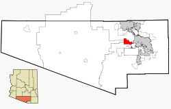
Lage im County und in Arizona
Basisdaten
Staat: Vereinigte Staaten
Bundesstaat: Arizona
County:

Pima County

Koordinaten: 32° 11′ N, 111° 7′ W32.180555555556-111.10944444444807Koordinaten: 32° 11′ N, 111° 7′ W
Zeitzone: Mountain Standard Time (UTC−7)
Einwohner: 9755 (Stand: 2000)
Bevölkerungsdichte: 107,3 Einwohner je km²
Fläche: 90,9 km² (ca. 35 mi²)
davon 90,9 km² (ca. 35 mi²) Land
Höhe: 807 m
FIPS: 04-77035
GNIS-ID: 0025245

Tucson Estates ist ein Census-designated place im Pima County im US-Bundesstaat Arizona. Sie hat 9755 Einwohner auf einer Fläche von 90,9 km². Die Bevölkerungsdichte liegt bei 107,3/km². Die Koordinaten sind 32°10'51" Nord, 111°6'35" West. Die Stadt liegt in der Nähe des Saguaro National Park-West und des Ironwood Forest National Park. Sie wird von der Arizona State Route 86 tangiert.


Wikimedia Foundation.

Игры ⚽ Поможем написать курсовую

Schlagen Sie auch in anderen Wörterbüchern nach:

  • Tucson Estates — Lugar designado por el censo de los Estados Unidos …   Wikipedia Español

  • Tucson Estates — Tucson Estates, AZ U.S. Census Designated Place in Arizona Population (2000): 9755 Housing Units (2000): 4891 Land area (2000): 35.086093 sq. miles (90.872561 sq. km) Water area (2000): 0.000000 sq. miles (0.000000 sq. km) Total area (2000):… …   StarDict's U.S. Gazetteer Places

  • Tucson Estates, AZ — U.S. Census Designated Place in Arizona Population (2000): 9755 Housing Units (2000): 4891 Land area (2000): 35.086093 sq. miles (90.872561 sq. km) Water area (2000): 0.000000 sq. miles (0.000000 sq. km) Total area (2000): 35.086093 sq. miles (90 …   StarDict's U.S. Gazetteer Places

  • Tucson Estates — Original name in latin Tucson Estates Name in other language State code US Continent/City America/Phoenix longitude 32.18758 latitude 111.09093 altitude 806 Population 12192 Date 2011 05 14 …   Cities with a population over 1000 database

  • Tucson Estates, Arizona — Infobox Settlement official name = Tucson Estates, Arizona settlement type = CDP imagesize = image caption = imagesize = image caption = mapsize = 250px map caption = Location in Pima County and the state of Arizona mapsize1 = map caption1 =… …   Wikipedia

  • Tucson, Arizona — Tucson redirects here. For other uses, see Tucson (disambiguation). Tucson   City   From upper left: Downtown Tucson Skyline, Pima County Courthouse, Old Main, Un …   Wikipedia

  • Corona de Tucson, Arizona —   CDP   Corona de Tucson and Santa Rita foothills …   Wikipedia

  • Greeley Estates — Infobox musical artist Name = Greeley Estates Img capt = Greeley Estates performing at Warped Tour 2006 in Vancouver, BC Img size = Landscape = Background = group or band Alias = Origin = Phoenix, Arizona, USA Genre = Post hardcore Screamo… …   Wikipedia

  • National Register of Historic Places listings in Pima County, Arizona — Location of Pima County in Arizona This is a list of the National Register of Historic Places listings in Pima County, Arizona. This is intended to be a complete list of the properties and districts on the National Register of Historic Places in… …   Wikipedia

  • Oro Valley, Arizona — Town of Oro Valley, Arizona   Town   View of Pusch Ridge in the Santa Catalina Mountains from Oro Valley. September 2004 …   Wikipedia

Share the article and excerpts

Direct link
Do a right-click on the link above
and select “Copy Link”