- Tumut Shire
-
Shire of Tumut 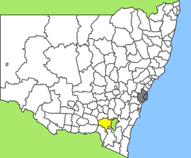
Lage des Tumut Shire in New South WalesGliederung Staat:  Australien
Bundesstaat:  New South Wales
Verwaltungssitz: Tumut Daten und Zahlen Fläche: 4.566 km² Einwohner: 10.801 (2006) [1] Bevölkerungsdichte: 2,4 Einwohner je km² -35.466666666667148.35Koordinaten: 35° 28′ S, 148° 21′ OTumut Shire ist ein lokales Verwaltungsgebiet (LGA) im australischen Bundesstaat New South Wales. Das Gebiet ist 4.566 km² groß und hat etwa 11.000 Einwohner.
Tumut liegt im Südosten des Staates und grenzt im Osten an die australische Hauptstadt Canberra. Das Gebiet umfasst 75 Ortsteile und Ortschaften, darunter Adelong, Argalaong, Batlow, Blowering, Brungle, Cabramurra, Gilmore, Gocup, Grahamstown, Kunama, Lacmalac, Minjary, Talbingo, Tumorrama, Tumut, Talbingo, Wondalga, Wyangle und Yarrangobilly. Der Sitz des Shire Councils befindet sich in der Stadt Tumut im Nordosten der LGA, wo etwa 6.000 Einwohner leben.
Verwaltung
Der Tumut Shire Council hat sieben Mitglieder, die von den Bewohnern der LGA gewählt werden. Tumut ist nicht in Bezirke untergliedert. Aus dem Kreis der Councillor rekrutiert sich auch der Mayor (Bürgermeister) des Councils.
Weblinks
- Offizielle Seite des Tumut Shire Council (englisch)
Einzelnachweise
- ↑ Australian Bureau of Statistics (25. Oktober 2007): Tumut Shire (A) (Local Government Area) (Englisch). 2006 Census QuickStats. Abgerufen am 6. April 2010.
Kategorie:- Local Government Area in New South Wales

Wikimedia Foundation.