- Uncompahgre River
-
Uncompahgre River 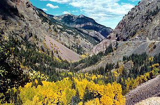
Der vom Uncompahgre-Fluss gebildete Uncompahgre-Gorge im Herbst
Daten Gewässerkennzahl US: 185397 Lage Colorado (USA) Flusssystem Colorado River Abfluss über Gunnison River → Colorado River → Golf von Kalifornien Quellsee Lake Como
37° 55′ 9″ N, 107° 37′ 11″ W37.9191623-107.61978223723Quellhöhe 3.723 m Mündung bei Delta in den Gunnison River 38.7566506-108.0903481498Koordinaten: 38° 45′ 24″ N, 108° 5′ 25″ W
38° 45′ 24″ N, 108° 5′ 25″ W38.7566506-108.0903481498Mündungshöhe 1.498 m Höhenunterschied 2.225 m Länge 121 km Durchflossene Stauseen Ridgway Reservoir Der Uncompahgre River ist ein 121 km langer Nebenfluss des Gunnison River im Südwesten des US-Bundesstaates Colorado. Er entspringt dem Lake Como (3.723 m), einem kleinen Bergsee im Uncompahgre National Forest im Norden des San Juan Countys. Er fließt nordwestlich durch die Bergdörfer Ouray, Ridgway, Montrose, Olathe und mündet im Confluence Park bei Delta in den Gunnison.
Der Fluss bildete in den Jahren die zwei Schluchten Poughkeepsie Gulch und Uncompahgre Gorge. Am Fluss gibt es zwei Talsperren: ein kleiner Staudamm in der Uncompahgre Gulch und ein weiterer Staudamm namens Ridgway Dam, der das Ridgway Reservoir staut. Der Name stammt vom Volk der Ute und bedeutet so viel wie „schmutziges Wasser“ oder „roter Wasser Frühling“[1].
Weblinks
- ↑ laut GNIS „Heißwasserquelle“
Kategorien:- Flusssystem Colorado River
- Fluss in Colorado
- Fluss in Nordamerika

Wikimedia Foundation.