- Utah Lake
-
Utahsee Blick auf den Utahsee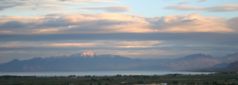

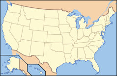
Geografische Lage: Großes Becken US-Bundesstaat: Utah Klassifizierung: Süßwassersee Fläche: 392 km² Max. Tiefe: 4,27 m Uferlänge: 122 km Höhe ü. NN: 1.368 m Zuflüsse: Provo Abflüsse: Jordan Inseln: 1 (Vogelinsel) Der Utahsee ist der größte Süßwassersee des US-Bundesstaat Utah. Er liegt südlich von Salt Lake City im nordöstlichen Teil des Großen Beckens und hat eine Wasserfläche von 392 km². Über den Fluss Jordan fließt er in den Großen Salzsee ab.
Der am Fuße der Wasatchkette gelegene See ist rund 39 km lang, bis zu 18 km breit und mit einer maximalen Tiefe von etwas mehr als vier Metern nicht sehr tief. Wasser wird ihm von den Bergen über viele kleine Bäche zugeführt, während er im Norden in den Großen Salzsee abläuft. Saisonal bilden sich auf dem See große Algenblüten, welche sich in der Vergangenheit am östlichen Ufer des Sees mit industriellen Zuflüssen eines inzwischen nicht mehr existierenden Stahlwerks vermischten.
Insbesondere die sumpfigen Gebiete am Südzipfel des Sees sowie die Gegend an der Mündung des Provo dienen im Frühjahr und den späten Herbstmonaten vielen Zugvögeln, wie Pelikanen, Gänsen und Reihern, als Rastplatz.
Der Utahsee liegt in einem nach dem See benannten State Park und ist beliebtes Ausflugsziel für Wassersportler und Angler. In den Wintermonaten friert der See zeitweilig zu und erlaubt Wintersportaktivitäten wie Schlittschuhlaufen.
 State Parks des US-Bundesstaates Utah
Anasazi Indian | Antelope Island | Bear Lake | Camp Floyd | Coral Pink Sand Dunes | Dead Horse Point | Deer Creek | East Canyon | Edge Of the Cedars | Escalante | Fremont Indian | Goblin Valley | Goosenecks | Green River | Großer Salzsee | Gunlock | Historic Union Pacific Rail Trail | Huntington | Hyrum | Iron Mission | Jordanelle | Kodachrome | Millsite | Otter Creek | Palisade | Piute | Quail Creek | Red Fleet | Rockport | Sand Hollow | Scofield | Snow Canyon | Starvation | Steinaker | Utah Territorial Statehouse | Utahsee | Wasatch Mountain | Willard Bay | Yuba Lake
40.183055555556-111.78305555556Koordinaten: 40° 10′ 59″ N, 111° 46′ 59″ W


Wikimedia Foundation.