- Bato (Camarines Sur)
-
Municipality of Bato Lage von Bato in der Provinz Camarines Sur 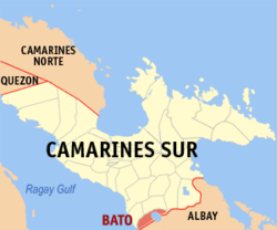
Basisdaten Bezirk: Bicol-Region Provinz: Camarines Sur Barangays: 33 Distrikt: 4. Distrikt von Camarines Sur PSGC: 051703000 Einkommensklasse: 3. Einkommensklasse Haushalte: 7737 Zensus 1. Mai 2000Einwohnerzahl: 44.437 Zensus 1. August 2007Bevölkerungsdichte: 450,1 Einwohner je km² Fläche: 98,720 km² Koordinaten: 13° 21′ N, 123° 22′ O13.356123.364Koordinaten: 13° 21′ N, 123° 22′ O Bürgermeister: Jeanette Bernaldez Geographische Lage auf den Philippinen 

Bato Bato ist eine philippinische Stadtgemeinde in der Provinz Camarines Sur. Nach dem Zensus vom 1. Mai 2000 hat sie 42.739 Einwohner in 7737 Haushalten.
Baranggays
Bato ist politisch in 33 Baranggays unterteilt.
- Agos
- Bacolod
- Buluang
- Caricot
- Cawacagan
- Cotmon
- Cristo Rey
- Del Rosario
- Divina Pastora (Pob.)
- Goyudan
- Lobong
- Lubigan
- Mainit
- Manga (Mangga)
- Masoli
- Neighborhood
- Niño Jesus
- Pagatpatan
- Palo
- Payak
- Sagrada (Sagrada Familia)
- Salvacion
- San Isidro (Pob.)
- San Juan
- San Miguel
- San Rafael (Pob.)
- San Roque
- San Vicente
- Santa Cruz (Pob.)
- Santiago (Pob.)
- Sooc
- Tagpolo
- Tres Reyes (Pob.)
Städte und Stadtgemeinden in der Provinz Camarines SurStädte: Iriga City | Naga City
Stadtgemeinden: Baao | Balatan | Bato | Bombon | Buhi | Bula | Cabusao | Calabanga | Camaligan | Canaman | Caramoan | Del Gallego | Gainza | Garchitorena | Goa | Lagonoy | Libmanan | Lupi | Magarao | Milaor | Minalabac | Nabua | Ocampo | Pamplona | Pasacao | Pili | Presentacion | Ragay | Sagñay | San Fernando | San Jose | Sipocot | Siruma | Tigaon | Tinambac
Wikimedia Foundation.
Schlagen Sie auch in anderen Wörterbüchern nach:
Bato, Camarines Sur — Infobox Philippine municipality infoboxtitle = Municipality of Bato sealfile = locatormapfile = Ph locator camarines sur bato.png| caption = Map of Camarines Sur showing the location of Bato region = Bicol Region (Region V) province = Camarines… … Wikipedia
Camarines Sur (Provinz) — Lage der Provinz Camarines Sur Camarines Sur ist eine Provinz der Philippinen im Bezirk V, welcher sich auf der Insel Luzon befindet. Die Hauptstadt der Provinz ist Pili. Camarines Sur ist mit 5267 km² die größte Provinz des Bezirkes. Insgesamt… … Deutsch Wikipedia
Camarines Sur — Lage der Provinz Camarines Sur Camarines Sur ist eine Provinz der Philippinen im Bezirk V, die sich im Südosten der Insel Luzon befindet. Die Hauptstadt der Provinz ist Pili. Camarines Sur ist mit 5267 km² die größte Provinz des Bezirkes.… … Deutsch Wikipedia
Camarines Sur — Infobox Philippine province name = Camarines Sur sealfile = Ph seal camarines sur.png region = Bicol Region (Region V) capital = Pili founded = mdash; pop2000 = 1,693,821 (2007) pop2000rank = 15th largest popden2000 = 295 popden2000rank = 22nd… … Wikipedia
Camarines Sur — 13° 40′ 00″ N 123° 19′ 59″ E / 13.6667, 123.333 … Wikipédia en Français
Nabua, Camarines Sur — Nabua Municipality Seal … Wikipedia
Ocampo, Camarines Sur — Ocampo Municipality Map of Camarines Sur showing the location of Ocampo … Wikipedia
Naga, Camarines Sur — City of Naga Ciudad nin Naga Lungsod ng Naga Seal Nickname(s) … Wikipedia
Magarao, Camarines Sur — Magarao Municipality Map of Camarines Sur showing the location of Magarao … Wikipedia
Minalabac, Camarines Sur — Minalabac Municipality Map of Camarines Sur showing the location of Minalabac … Wikipedia
Bato (Camarines Sur)


18+
© Academic, 2000-2024
- Kontaktieren Sie uns: Unterstützung, Werbung
Wörterbücher Export, schritte mit PHP, Joomla, Drupal, WordPress, MODx.