- Vincenzo A. Sagun
-
Municipality of Vincenzo A. Sagun Lage von Vincenzo A. Sagun in der Provinz Zamboanga del Sur 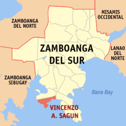
Basisdaten Bezirk: Zamboanga Peninsula Provinz: Zamboanga del Sur Barangays: 14 Distrikt: 2. Distrikt von Zamboanga del Sur PSGC: 097341000 Einkommensklasse: 5. Einkommensklasse Haushalte: 3679 Zensus 1. Mai 2000Einwohnerzahl: 19.984 Zensus 1. August 2007Koordinaten: 7° 31′ N, 123° 9′ O7.5166666666667123.15Koordinaten: 7° 31′ N, 123° 9′ O Postleitzahl: 7036 Bürgermeister: Edilberto S. Adlaon Geographische Lage auf den Philippinen 

Vincenzo A. Sagun Vincenzo A. Sagun ist eine philippinische Stadtgemeinde in der Provinz Zamboanga del Sur. Nach dem Zensus vom 1. Mai 2000 hat sie 19.072 Einwohner in 3679 Haushalten.
Baranggays
Vincenzo A. Sagun ist politisch in 14 Baranggays unterteilt.
- Ambulon
- Bui-os
- Cogon
- Danan
- Kabatan
- Kapatagan
- Limason
- Linoguayan
- Lumbal
- Lunib
- Maculay
- Maraya
- Sagucan
- Waling-waling
Städte und Stadtgemeinden in der Provinz Zamboanga del SurStädte: Pagadian City
Stadtgemeinden: Aurora | Bayog | Dimataling | Dinas | Dumalinao | Dumingag | Guipos | Josefina | Kumalarang | Labangan | Lakewood | Lapuyan | Mahayag | Margosatubig | Midsalip | Molave | Pitogo | Ramon Magsaysay | San Miguel | San Pablo | Sominot | Tabina | Tambulig | Tigbao | Tukuran | Vincenzo A. Sagun
Wikimedia Foundation.
Schlagen Sie auch in anderen Wörterbüchern nach:
Vincenzo A. Sagun, Zamboanga del Sur — Vincenzo A. Sagun is a 5th class municipality in the province of Zamboanga del Sur, Philippines. According to the 2000 census, it has a population of 19,072 people in 3,679 households.BarangaysVincenzo A. Sagun is politically subdivided into 14… … Wikipedia
Legislative districts of Zamboanga del Sur — Philippines This article is part of the series: Politics and government of the Philippines … Wikipedia
PH-ZAS — Lage von Zamboanga del Sur Die Provinz Zamboanga del Sur besetzt die südöstliche Ecke der Halbinsel Zamboanga. Diese ist ein Ausläufer der Insel Mindanao, der größten Insel im Süden der Philippinen. Die Hauptstadt der Provinz ist Pagadian City.… … Deutsch Wikipedia
Dinas, Zamboanga del Sur — Dinas Municipality Coordinates … Wikipedia
Dumalinao, Zamboanga del Sur — Dumalinao Municipality Map of Zamboanga del Sur showing the location of Dumalinao … Wikipedia
Dumingag, Zamboanga del Sur — Dumingag Municipality Map of Zamboanga del Sur showing the location of Dumingag … Wikipedia
Dimataling, Zamboanga del Sur — Dimataling Municipality Map of Zamboanga del Sur showing the location of Dimataling … Wikipedia
Mahayag, Zamboanga del Sur — Mahayag Municipality Town hall … Wikipedia
Margosatubig, Zamboanga del Sur — Margosatubig Margos Municipality Map of Zam … Wikipedia
Molave, Zamboanga del Sur — Molave redirects here. This can also refer to the wood of Vitex cofassus and Vitex parviflora. Molave Municipality … Wikipedia
Vincenzo A. Sagun


18+
© Academic, 2000-2024
- Kontaktieren Sie uns: Unterstützung, Werbung
Wörterbücher Export, schritte mit PHP, Joomla, Drupal, WordPress, MODx.