- Wallowa County
-
 Wallowa County Courthouse in Enterprise
Verwaltung US-Bundesstaat: Oregon Verwaltungssitz: Enterprise (Oregon) Gründung: 1864 Demographie Einwohner: 7226 (2000) Bevölkerungsdichte: 0,9 Einwohner/km² Geographie Fläche gesamt: 8.163 km² Wasserfläche: 16 km² Karte 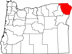
Website: www.co.wallowa.or.us Wallowa County[1] ist ein County im Bundesstaat Oregon der Vereinigten Staaten von Amerika mit 7226 Einwohnern. Der Sitz der Countyverwaltung (County Seat) befindet sich in Enterprise.
Inhaltsverzeichnis
Geografie
Das County hat eine Fläche von 8163 Quadratkilometern; davon sind 16 Quadratkilometer (0,2 Prozent) Wasserfläche.
Demografische Daten
Historische Einwohnerzahlen Census Einwohner ± in % 1890 3661 — 1900 5538 50 % 1910 8364 50 % 1920 9778 20 % 1930 7814 -20 % 1940 7623 -2 % 1950 7264 -5 % 1960 7102 -2 % 1970 6247 -10 % 1980 7273 20 % 1990 6911 -5 % 2000 7226 5 % Vor 1900[2]  Alterspyramide des Wallowa Countys (Stand: 2000)
 Der Maxwell Lake in der Eagle Cap Wilderness
Nach der Volkszählung im Jahr 2000 lebten im County 7.226 Menschen. Es gab 3.029 Haushalte und 2.083 Familien. Die Bevölkerungsdichte betrug 1 Einwohner pro Quadratkilometer. Ethnisch betrachtet setzte sich die Bevölkerung zusammen aus 96,50% Weißen, 0,03% Afroamerikanern, 0,71% amerikanischen Ureinwohnern, 0,24% Asiaten, 0,04% Bewohnern aus dem pazifischen Inselraum und 0,95% Prozent aus anderen ethnischen Gruppen; 1,54% stammten von zwei oder mehr ethnischen Gruppen ab. 1,73% der Bevölkerung waren spanischer oder lateinamerikanischer Abstammung.
Von den 3.029 Haushalten hatten 28,50% Kinder und Jugendliche unter 18 Jahre, die bei ihnen lebten. 58,70% waren verheiratete, zusammenlebende Paare, 6,90% waren allein erziehende Mütter. 31,20% waren keine Familien. 27,10% waren Singlehaushalte und in 11,90% lebten Menschen im Alter von 65 Jahren oder darüber. Die Durchschnittshaushaltsgröße betrug 2,35 und die durchschnittliche Familiengröße lag bei 2,85 Personen.
Auf das gesamte County bezogen setzte sich die Bevölkerung zusammen aus 24,30% Einwohnern unter 18 Jahren, 4,90% zwischen 18 und 24 Jahren, 21,90% zwischen 25 und 44 Jahren, 30,00% zwischen 45 und 64 Jahren und 18,90% waren 65 Jahre alt oder darüber. Das Durchschnittsalter betrug 44 Jahre. Auf 100 weibliche Personen kamen 100,10 männliche Personen, auf 100 Frauen im Alter ab 18 Jahren kamen statistisch 96,10 Männer.
Das jährliche Durchschnittseinkommen eines Haushalts betrug 32.129 USD, das Durchschnittseinkommen der Familien betrug 38.682 USD. Männer hatten ein Durchschnittseinkommen von 28.202 USD, Frauen 21.558 USD. Das Prokopfeinkommen betrug 17.276 USD. 14,00% der Bevölkerung und 9,80% der Familien lebten unterhalb der Armutsgrenze. 18,30% davon waren unter 18 Jahre und 11,40% waren 65 Jahre oder älter.
Einzelnachweise
- ↑ Wallowa County im Geographic Names Information System des United States Geological Survey. Abgerufen am 22. Februar 2011
- ↑ U.S. Census Bureau - Census of Population and Housing. Abgerufen am 15. März 2011
- ↑ Auszug aus Census.gov. Abgerufen am 28. Februar 2011
- ↑ Auszug aus factfinder.census.gov Abgerufen am 28. Februar 2011
Weblinks
 Commons: Wallowa County, Oregon – Sammlung von Bildern, Videos und Audiodateien
Liste der Countys in Oregon
Baker | Benton | Clackamas | Clatsop | Columbia | Coos | Crook | Curry | Deschutes | Douglas | Gilliam | Grant | Harney | Hood River | Jackson | Jefferson | Josephine | Klamath | Lake | Lane | Lincoln | Linn | Malheur | Marion | Morrow | Multnomah | Polk | Sherman | Tillamook | Umatilla | Union | Wallowa | Wasco | Washington | Wheeler | Yamhill
Wikimedia Foundation.
Schlagen Sie auch in anderen Wörterbüchern nach:
Wallowa County — Admin ASC 2 Code Orig. name Wallowa County Country and Admin Code US.OR.063 US … World countries Adminstrative division ASC I-II
Wallowa County, Oregon — Infobox U.S. County county = Wallowa County state = Oregon map size = 225 founded = October 14, 1864 seat = Enterprise | area total sq mi =3152 area land sq mi =3145 area water sq mi =6 area percentage = 0.20% census yr = 2000 pop = 7226 density… … Wikipedia
Wallowa County (Oregon) — Verwaltung US Bundesstaat: Oregon Verwaltungssitz: Enterprise (Oregon) Adresse des Verwaltungssitzes: Gründung: 1864 … Deutsch Wikipedia
National Register of Historic Places listings in Wallowa County, Oregon — This is a list of properties and districts in Wallowa County, Oregon that are listed on the National Register of Historic Places. Map of all coordinates from Google Map of all coordinates from Bing … Wikipedia
Dollar Lake (Wallowa County, Oregon) — Dollar Lake Location Eagle Cap Wilderness, Wallowa County, Oregon, USA Coordinates … Wikipedia
Wallowa — may refer to the Wallowa band of the Nez Perce or to various geographical entities in the northeastern part of the U.S. state of Oregon named after them:*Wallowa County, Oregon *The city of Wallowa, Oregon *The Wallowa River *The Wallowa… … Wikipedia
Wallowa-Whitman National Forest — Infobox protected area | name = Wallowa Whitman National Forest iucn category = V caption = Location in Oregon and Idaho locator x = 41 locator y = 31 location = Oregon and Idaho, USA nearest city = Baker City, Oregon lat degrees = 45 lat minutes … Wikipedia
Wallowa River — The Wallowa River is a tributary of the Grande Ronde River, approximately 30 miles (48 km) long, in northeastern Oregon in the United States. It drains a valley on the Columbia Plateau in the northeast corner of the state north of Wallowa… … Wikipedia
Wallowa Lake State Park — Infobox park park= Wallowa Lake State Park image size=250px caption=Wallowa Lake type=Public, state location=Wallowa County, Oregon, United States coordinates= size= opened= operator=Oregon State Parks and Recreation Department annual visitors=… … Wikipedia
Wallowa, Oregon — Infobox Settlement official name = Wallowa, Oregon settlement type = City nickname = motto = imagesize = image caption = image imagesize = image caption = image mapsize = 250px map caption = Location in Oregon mapsize1 = map caption1 =… … Wikipedia
Wallowa County


18+
© Academic, 2000-2024
- Kontaktieren Sie uns: Unterstützung, Werbung
Wörterbücher Export, schritte mit PHP, Joomla, Drupal, WordPress, MODx.