Wellington Council

Wellington Council
Wellington
Australia-Map-NSW-LGA-Wellington.png
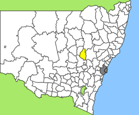
Lage des Wellington Council in New South Wales
Gliederung
Staat: Australien Australien
Bundesstaat: Flag of New South Wales.svg New South Wales
Verwaltungssitz: Wellington
Daten und Zahlen
Fläche: 4.113 km²
Einwohner: 8.120 (2006) [1]
Bevölkerungsdichte: 2 Einwohner je km²
-32.55148.95

Wellington ist ein lokales Verwaltungsgebiet (LGA) im australischen Bundesstaat New South Wales. Das Gebiet ist 4.113 km² groß und hat etwa 8.400 Einwohner.

Wellington Council liegt in der Region North Western des Staates etwa 350 km nordwestlich der Metropole Sydney und 350 km nördlich der australischen Hauptstadt Canberra. Das Gebiet umfasst 58 Ortsteile und Ortschaften, darunter Bodangora, Cundumbul, Dripstone, Elong Elong, Euchareena, Finger Post, Gollan, Maryvale, Mumbil, Muronbung, Neurea, Stuart Town, Twelve Mile, Walmer, Wellington sowie Teile von Arthurville, Ballimore, Geurie und Yeoval. Der Verwaltungssitz des Councils befindet sich in der Stadt Wellington im Zentrum der LGA, wo etwa 4.700 Einwohner leben.

Verwaltung

Der Council von Wellington hat neun Mitglieder, die von den Bewohnern der LGA gewählt werden. Wellington ist nicht in Bezirke untergliedert. Aus dem Kreis der Councillor rekrutiert sich auch der Mayor (Bürgermeister) des Councils.

Weblinks

Einzelnachweise

  1. Australian Bureau of Statistics (25. Oktober 2007): Wellington (A) (Local Government Area) (Englisch). 2006 Census QuickStats. Abgerufen am 6. April 2010.

Wikimedia Foundation.

Игры ⚽ Поможем написать реферат

Schlagen Sie auch in anderen Wörterbüchern nach:

  • Wellington Council — Infobox Australian Place | type = lga name = Wellington Council caption = Location in New South Wales state=New South Wales region=Orana area=4113 est = seat=Wellington (Nanima Crescent} cite web title=Wellington Council publisher = Department of …   Wikipedia

  • Wellington Shire — could refer to either of two Local Government Areas in Australia*Shire of Wellington in Victoria *Wellington Council in New South Wales …   Wikipedia

  • Wellington, New South Wales — Infobox Australian Place | type = town name = Wellington state = nsw caption = lga = Wellington Council postcode = 2820 est = pop = 4,692 elevation= 305 maxtemp = 24.3 mintemp = 9.4 rainfall = 614.5 stategov = Orange fedgov = Parkes dist1 = 360… …   Wikipedia

  • Wellington International Airport — Wellington Airport redirects here. For other uses, see Wellington Airport (disambiguation). Wellington International Airport Aerial photo of Wellington International Airport (north to left) IATA: WLG – …   Wikipedia

  • Wellington (Region) — Karte Basisdaten Hau …   Deutsch Wikipedia

  • Wellington Academy — was a secondary school in Greenock, Scotland serving the Eastern and Central areas of the town. It was opened in August 1990, as a result of a controversial mergerFact|date=December 2007 with Cowdeknowes High School (now Notre Dame RC High… …   Wikipedia

  • Wellington City — Council Karte Basisdaten Region …   Deutsch Wikipedia

  • Wellington Harbour — is the large natural harbour on the southern tip of New Zealand s North Island. New Zealand s capital, Wellington, is located on the western side of Wellington Harbour. The harbour was officially named Port Nicholson [… …   Wikipedia

  • Wellington Boone — is an American evangelical Christian leader, church planter, and author.HistoryBoone was ordained into ministry in 1973 where begain his ministry with Word of Faith seminars, and soon established churches in Ettrick and Richmond, Virginia, that… …   Wikipedia

  • Wellington — Wellington …   Deutsch Wikipedia

Share the article and excerpts

Direct link
Do a right-click on the link above
and select “Copy Link”