- Wokingham (District)
-
Wokingham District 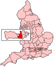
Basisdaten Status Unitary Authority, Borough Region South East England Zerem. Grafschaft Berkshire Verwaltungssitz Wokingham Fläche 178,98 km² (197.) Einwohner (2007) 156.600 (107.) ONS-Code 00MF Website www.wokingham.gov.uk Wokingham ist eine Unitary Authority und ein Borough in der Grafschaft Berkshire in England. Der Verwaltungssitz ist die Stadt Wokingham; weitere bedeutende Orte sind Earley, Finchampstead und Twyford.
Die Gebietskörperschaft wurde am 1. April 1974 als District Wokingham gegründet und entstand aus der Fusion der Borough Wokingham und des Rural District Wokingham. Als am 1. April 1998 der Grafschaftsrat von Berkshire aufgelöst wurde, erhielt der District den Status einer Unitary Authority.
 Verwaltungsgrafschaften und Unitary Authorities in England
Grafschaften Englands mit zweistufiger Verwaltung (Non-Metropolitan Counties)
Buckinghamshire | Cambridgeshire | Cumbria | Derbyshire | Devon | Dorset | East Sussex | Essex | Gloucestershire | Hampshire | Hertfordshire | Kent | Lancashire | Leicestershire | Lincolnshire | Norfolk | Northamptonshire | North Yorkshire | Nottinghamshire | Oxfordshire | Somerset | Staffordshire | Suffolk | Surrey | Warwickshire | West Sussex | WorcestershireUnitary Authorities
Bath and North East Somerset | Bedford | Blackburn with Darwen | Blackpool | Bournemouth | Bracknell Forest | Brighton and Hove | Bristol | Central Bedfordshire | Cheshire East | Cheshire West and Chester | Cornwall | County Durham | Darlington | Derby | East Riding of Yorkshire | Halton | Hartlepool | Herefordshire | Isle of Wight | Isles of Scilly | Kingston upon Hull | Leicester | Luton | Medway | Middlesbrough | Milton Keynes | North East Lincolnshire | North Lincolnshire | North Somerset | Northumberland | Nottingham | Peterborough | Plymouth | Poole | Portsmouth | Reading | Redcar and Cleveland | Rutland | Shropshire | Slough | Southampton | Southend-on-Sea | South Gloucestershire | Stockton | Stoke-on-Trent | Swindon | Telford and Wrekin | Thurrock | Torbay | Warrington | West Berkshire | Wiltshire | Windsor and Maidenhead | Wokingham | York
Wikimedia Foundation.
Schlagen Sie auch in anderen Wörterbüchern nach:
Wokingham (borough) — Wokingham is a local government district in Berkshire, United Kingdom. It is named after its main town, Wokingham. Other places in the district include Arborfield, Barkham, Charvil, Earley, Finchampstead, Hurst, Sonning, Remenham, Ruscombe,… … Wikipedia
Wokingham Without — is a civil parish in the Wokingham district of the English county of Berkshire. It was formed in 1894 when the parish of Wokingham was split into two one rural and one urban.The parish originally curved around Wokingham proper from north to south … Wikipedia
Wokingham — infobox UK place country = England official name= Wokingham latitude= 51.41 longitude= 0.84 population= 30,403 (2001 Census) civil parish= Wokingham unitary england= Wokingham region= South East England lieutenancy england= Berkshire constituency … Wikipedia
Wokingham Rural District — infobox historic subdivision Name= Wokingham HQ= Wokingham Status= Rural district Start= 1894 End= 1974 Replace= Wokingham District Wokingham Rural District was a rural district in the county of Berkshire, England. It was created in 1894. It was… … Wikipedia
Wokingham local elections — One third of Wokingham Council is elected each year, followed by one year without election.Political control* Conservative 1997–2000 * No overall control 2000–2002 * Conservative 2002–presentCouncil elections* Wokingham Council election, 1999 *… … Wikipedia
Wokingham (UK Parliament constituency) — UK constituency infobox Name = Wokingham Map1 = Wokingham Map2 = Berkshire Type = County Year = 1885, 1950 Entity = Berkshire County = Berkshire EP = South East England MP = John Redwood Party = ConservativeWokingham is a parliamentary… … Wikipedia
District of Wokingham — Admin ASC 2 Code Orig. name District of Wokingham Country and Admin Code GB.ENG.Q2 GB … World countries Adminstrative division ASC I-II
List of District Health Authorities in England and Wales — District Health Authorities were administrative units of the National Health Service in England and Wales from 1982 to 1996. The districts were a second tier below the health regions. They replaced the Area Health Authorities (which generally… … Wikipedia
Adur (district) — Adur District Non metropolitan district Adur shown within West Sussex Sovereign state … Wikipedia
Cherwell (district) — For other uses, see Cherwell (disambiguation). Cherwell District Non metropolitan district Cherwell shown within Oxfordshire … Wikipedia
Wokingham (District)

18+
© Academic, 2000-2024
- Kontaktieren Sie uns: Unterstützung, Werbung
Wörterbücher Export, schritte mit PHP, Joomla, Drupal, WordPress, MODx.