- Xhariep
-
Xhariep
Xhariep District Municipality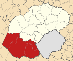
Basisdaten Staat Südafrika Provinz Freistaat Sitz Trompsburg Fläche 34.249,4 km² Einwohner 127.629 (24. Oktober 2007) Dichte 3,7 Einwohner pro km² Schlüssel DC16 ISO 3166-2 ZA-FS Webauftritt www.xhariep.co.za (englisch) Politik Bürgermeister Mongi Ntwanambi -30.01666666666725.766666666667Koordinaten: 30° 1′ S, 25° 46′ ODer Distrikt (District Municipality) Xhariep ist Teil der Provinz Freistaat in Südafrika. Auf einer Fläche von 34.249 km² leben 135.225 Einwohner (Stand 2001). Die Hauptstadt ist Trompsburg. [1]
Der Bezirksname ist das Griqua-Wort für den Gariep (Orange River). [2]
Inhaltsverzeichnis
Gemeindestruktur
Als Beispiel für die Infrastruktur hier die Wasserversorgung der Haushalte (HWA = eigener Hauswasseranschluss; ÖWA = öffentlicher Wasseranschluss in der Nähe; KWA = kein Anschluss an ein Wasserleitungsnetz) [3]:
Gemeinde Verwaltungssitz Fläche Einwohner H W A Ö W A K W A Letsemeng Koffiefontein 10.225 km² 42.975 16% 67% 17% Mohokare Zastron 8.776 km² 36.314 9% 73% 18% Kopanong Trompsburg 15.248 km² 55.936 12% 75% 13% Nationalparks/Naturschutzgebiete
- Gariep Dam Nature Reserve
- Tussen-die-Riviere Nature Reserve
- Kalkfontein Nature Reserve
Private Naturschutzgebiete
- Gemsbokpark Private Nature Reserve – Fauresmith (473 ha)
- Little Motopos Game Ranch – Edenburg (1.000 ha)
- Nep Farm Nature Reserve – Fauresmith (700 ha)
- Sandymount Park – Fauresmith (4.900 ha)
- Thanda Tula Reserve – Fauresmith (2.792 ha)
- Veldkraal Game Reserve – Edenburg (1.500 ha)
Weblinks/Quellen
Distrikte des südafrikanischen Freistaates (Vrystaat)Fezile Dabi | Lejweleputswa | Motheo | Thabo Mofutsanyane | Xhariep
Wikimedia Foundation.
Schlagen Sie auch in anderen Wörterbüchern nach:
Xhariep District Municipality — Xhariep is one of the 5 districts of Free State province of South Africa. The seat of Xhariep is Trompsburg. The largest language group in the 135 253 people is Afrikaans (2001 Census). The district code is DC16.GeographyNeighboursXhariep is… … Wikipedia
Xhariep District Municipality — Admin ASC 2 Code Orig. name Xhariep District Municipality Country and Admin Code ZA.03.DC16 ZA … World countries Adminstrative division ASC I-II
Free State — Vrystaat Freistaat Wappen Basisdaten Hauptstadt: Bloemfontein Fläche: Rang: in % Südafrikas … Deutsch Wikipedia
Free State Provinz — Free State Vrystaat Freistaat Wappen Basisdaten Hauptstadt: Bloemfontein Fläche: Rang: in % Südafrikas … Deutsch Wikipedia
Oranje Freestate — Free State Vrystaat Freistaat Wappen Basisdaten Hauptstadt: Bloemfontein Fläche: Rang: in % Südafrikas … Deutsch Wikipedia
Liste der Gemeinden Südafrikas — Dies ist eine Liste der südafrikanischen Gemeinden. Inhaltsverzeichnis 1 Metropolgemeinden 2 Freistaat 2.1 Xhariep – Xhariep District Municipality (DC16) 2.2 … Deutsch Wikipedia
Mohokare Local Municipality — Local municipality Location in … Wikipedia
Motheo District Municipality — District municipality A map of the … Wikipedia
Bethulie — Bethulie … Deutsch Wikipedia
Distrikte Südafrikas — (nummeriert) Südafrika ist in 52 Distrikte aufgeteilt. Es gibt 6 Metropolitan (gekennzeichnet mit *) und 46 District Municipalitys). Inhaltsverzeichnis 1 Westkap 2 Ostkap … Deutsch Wikipedia
Xhariep

18+
© Academic, 2000-2024
- Kontaktieren Sie uns: Unterstützung, Werbung
Wörterbücher Export, schritte mit PHP, Joomla, Drupal, WordPress, MODx.