- Youngstown (New York)
-
Youngstown 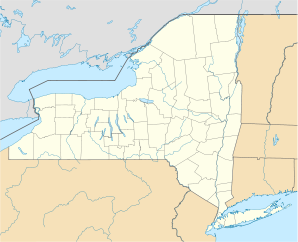

Youngstown Lage in New YorkBasisdaten Staat: Vereinigte Staaten Bundesstaat: New York County: Koordinaten: 43° 15′ N, 79° 3′ W43.248752777778-79.04252222222290Koordinaten: 43° 15′ N, 79° 3′ W Zeitzone: Eastern Standard Time (UTC−5) Einwohner: 1957 (Stand: 2005) Bevölkerungsdichte: 652,3 Einwohner je km² Fläche: 3,6 km² (ca. 1 mi²)
davon 3,0 km² (ca. 1 mi²) LandHöhe: 90 m Postleitzahl: 14174 Vorwahl: +1 716 FIPS: 36-84143 GNIS-ID: 0971860 Webpräsenz: www.northofthefalls.com/chamber/webcapsule/youngstown/index.shtml Youngstown ist ein Village im westlichen Teil von Niagara County, New York, Vereinigte Staaten von Amerika. Bei der Volkszählung von 2000 wurden 1957 Einwohner gezählt.
Der Ort befindet sich am östlichen Ufer des Niagara River und somit an der Grenze zu Kanada. An der gegenüberliegenden Flussseite liegt die etwa 14.000 Einwohner zählende Stadt Niagara-on-the-Lake.
Geschichte
Etwa einen Kilometer nördlich vom heutigen Stadtkern errichtete der französische Entdecker Robert Cavelier de La Salle im Jahr 1670 einen kleines Fort. Um dieses Fort begannen sich Siedler niederzulassen, was die Ursprünge von Youngstown darstellen. Die Befestigungsanlage wurde stetig ausgebaut und wurde zum Herzstück des späteren Fort Niagara.[1] Während des Britisch-Amerikanischen Krieges 1812 wurde die Siedlung komplett zerstört.
Söhne und Töchter der Stadt
- Daryl Johnston, American-Football-Spieler, Fernsehmoderator
Einzelnachweise
- ↑ Youngstown: Village is steeped in history (englisch)
Kategorie:- Ort in New York

Wikimedia Foundation.