- Bharathapuzha
-
Bharathapuzha 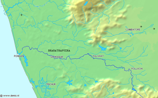
Lage des Bharathapuzha
Daten Lage Kerala, Tamil Nadu (Indien) Flusssystem Bharathapuzha Quelle in den Westghats in Tamil Nadu
10° 36′ 0″ N, 77° 7′ 0″ O10.677.1166666666672461Quellhöhe 2.461 m Mündung in das Arabische Meer 10.7866575.9103490Koordinaten: 10° 47′ 12″ N, 75° 54′ 37″ O
10° 47′ 12″ N, 75° 54′ 37″ O10.7866575.9103490Mündungshöhe 0 m Höhenunterschied 2.461 m Länge 209 km Einzugsgebiet 6.186 km² Abflussmenge
am Pegel MündungMQ: 161 m³/s Mittelstädte Pollachi, Shoranur, Ponnani 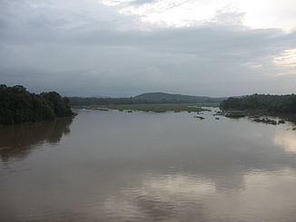
Der Bharathapuzha bei Shoranur zur Monsunzeit
Der Bharathapuzha (Malayalam: ഭാരതപ്പുഴ Bhāratappuḻa [ˈbʱaːɾat̪əpːuɻa]; auch: Ponnani) ist ein Fluss im südindischen Bundesstaat Kerala.
Der 209 km lange Fluss entspringt auf einer Höhe von 2461 m in den Westghats in Tamil Nadu und durchfließt die Distrikte Palakkad und Malappuram, ehe er in Ponnani in das Arabische Meer mündet. Der Bharathapuzha wird von sechs Staudämmen gestaut, zwei weitere Anlagen befinden sich im Bau. Hauptsächlich dienen sie der Bewässerung, es gibt auch ein Projekt zur Trinkwasserversorgung.
Weblinks
 Commons: Bharathapuzha – Sammlung von Bildern, Videos und AudiodateienKategorien:
- Fluss in Asien
- Fluss in Indien
- Geographie (Tamil Nadu)
- Geographie (Kerala)


Wikimedia Foundation.