- Blue Marble
-
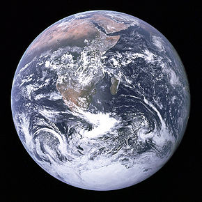 Foto der Erde, aufgenommen von Apollo 17
Blue Marble (englisch für Blaue Murmel) ist der Name für ein bekanntes Foto der Erde, das die Besatzung von Apollo 17 im Jahr 1972 aus einer Entfernung von 45.000 km aufnahm. Das Bild wurde unter anderen im Rahmen der Umweltschutzbewegung der 1970er Jahre auf Postern, Fahnen und T-Shirts populär.
Inhaltsverzeichnis
Die originale Blue Marble
Das Foto trägt die offizielle Bezeichnung AS17-148-22727 und wurde am 7. Dezember 1972 um 10:39 UTC mit einer 70-Millimeter-Hasselblad-Mittelformatkamera und einem 80-Millimeter-Festbrennweite-Objektiv aufgenommen. Es ist eine der wenigen Aufnahmen, die einen voll erleuchteten Erdball zeigen, da die Astronauten die Sonne hinter sich hatten. Die Originalaufnahme zeigt den Südpol oben. Wegen der besseren Wiedererkennbarkeit wurde die Fotografie um 180 Grad gedreht.[1] Die Original-Bildbeschreibung der Fotografie lautet:[2]
“View of the Earth as seen by the Apollo 17 crew traveling toward the moon. This translunar coast photograph extends from the Mediterranean Sea area to the Antarctica south polar ice cap. This is the first time the Apollo trajectory made it possible to photograph the south polar ice cap. Note the heavy cloud cover in the Southern Hemisphere. Almost the entire coastline of Africa is clearly visible. The Arabian Peninsula can be seen at the northeastern edge of Africa. The large island off the east coast of Africa is the Republic of Madagascar. The Asian mainland is on the horizon toward the northeast.”
„Ansicht der Erde, wie sie von der Mannschaft von Apollo 17 auf dem Weg zum Mond gesehen wurde. Dieses Mondflug-Foto erstreckt sich vom Mittelmeer bis zur Eiskappe der Antarktis. Zum ersten Mal ermöglichte es die Apollo-Flugbahn, die antarktische Eiskappe zu fotografieren. Beachten Sie die dichte Wolkendecke über der südlichen Halbkugel. Fast die ganze Küste Afrikas ist klar sichtbar. Die arabische Halbinsel ist am nordöstlichen Rand von Afrika sichtbar. Die große Insel vor der Ostküste Afrikas ist die Republik Madagaskar. Das asiatische Festland befindet sich am nordöstlichen Horizont.“
Die Blue Marble-Serie der NASA
 The Blue Marble: Land Surface, Ocean Color and Sea Ice als Quadratische Plattkarte (equirektangulare Projektion)
Die NASA bezeichnet Collagen aus vielen Satellitenfotos, die eine ähnliche Perspektive zeigen, ebenfalls als Blue Marble. Aktuell ist die Serie Blue Marble: Next Generation, die die Erde im monatlichen Wechsel wiedergibt. Die Bilder basieren auf den Daten der Satelliten Terra und Aqua. Sie erreichen eine Auflösung von bis zu 500 m/Pixel. Wie alle ihre Fotos hat die NASA auch Bilder der Blue-Marble-Serien zur freien Nutzung in die öffentliche Hand gegeben.[3]
Ein Auszug daraus ist die Blue Marble: Cloudless Earth von 2002, eine wolkenbereinigte Gesamtansicht der Erde. Sie ist die Basis vieler Anwendungen, etwa NASA World Wind. Auch diese Grafik ist frei verwendbar und hat (in maximaler Auflösung im TIFF-Format) etwa 31 Megabyte.
Siehe auch
Weblinks
 Commons: The Blue Marble – Sammlung von Bildern, Videos und Audiodateien
-
 Wiktionary: marble – Bedeutungserklärungen, Wortherkunft, Synonyme, Übersetzungen
 - Apollo Image Atlas Fotos aus dem NN Magazin, aufgenommen mit der 70-mm-Hasselblad-Kamera während Apollo 17
- The Blue Marble: Land Surface, Ocean Color and Sea Ice (englisch)
- Blue Marble Next Generation (Projektseite, englisch)
- das Originalbild (TIFF, ca. 40 MB)
Einzelnachweise
- ↑ Für die ursprüngliche Aufnahme siehe Apollo Image Atlas AS17-148-22727, Lunar and Planetary Institute
- ↑ The Gateway to Astronaut Photography of Earth: [1] (link nicht mehr verfügbar)
- ↑ Hinweise auf nasa.gov
-


Wikimedia Foundation.