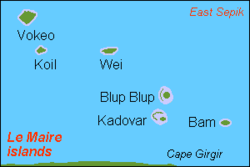
Blupblup

Blupblup
Übersichtskarte

Blup Blup, früher auch Garnot-Insel genannt, ist eine kleine Vulkaninsel des südpazifischen Inselstaates Papua-Neuguinea (Provinz East Sepik).

Blup Blup gehört zu den Le-Maire-Inseln und liegt etwa 60 km östlich vom Festland (Kap Girgir). Der höchste Punkt der etwa 3,5 km² großen Insel liegt 402 m über Meeresniveau.

Die Insel ist unbewohnt. In unmittelbarer Nähe befindet sich – auf einer weit kleineren Nachbarinsel – eine automatisierte Wetterstation.

Quellen & Weblinks

-3.5166666666667144.67Koordinaten: 3° 31′ S, 144° 36′ O


Wikimedia Foundation.

Игры ⚽ Нужно решить контрольную?

Schlagen Sie auch in anderen Wörterbüchern nach:

  • Blup Blup — Island is a small forested island of the northern coast of Papua New Guinea about 30km offshore from Cape Girgir and is considered part of the Schouten Islands. It is located at Latitude S 3°30 46 and Longitude E 144°35 16 . The island has a… …   Wikipedia

  • Liste deutscher Bezeichnungen papua-neuguineischer Orte — Ortsbezeichnungen in den ehemaligen deutschen Kolonien im Bismarck Archipel und Papua Neuguinea Inhaltsverzeichnis A B C D E F G H I J K L M N O P Q R S T U V W X Y Z …   Deutsch Wikipedia

Share the article and excerpts

Direct link
Do a right-click on the link above
and select “Copy Link”