Bourke Shire

Bourke Shire
Bourke Shire
Australia-Map-NSW-LGA-Bourke.png
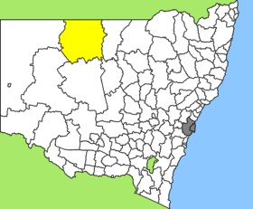
Lage des Bourke Shire in New South Wales
Gliederung
Staat: Australien Australien
Bundesstaat: Flag of New South Wales.svg New South Wales
Verwaltungssitz: Bourke
Daten und Zahlen
Fläche: 41.679 km²
Einwohner: 3.095 (2006) [1]
Bevölkerungsdichte: 0,07 Einwohner je km²
-30.1145.93333333333

Bourke Shire ist ein lokales Verwaltungsgebiet (LGA) im australischen Bundesstaat New South Wales. Das Gebiet ist 41.679 km² groß und hat etwa 3.100 Einwohner.

Bourke liegt an der Nordgrenze zu Queensland am Darling River in der North-Western-Region etwa 780 km nordwestlich der Metropole Sydney. Das Gebiet umfasst 29 Ortsteile und Ortschaften: Barringun, Beemery, Belalie, Boorindal, Bourke, Brindingabba, Cornerstone Community, Dry Lake, Enngonia, Fords Bridge, Grass Hut, Gumbalie, Gunderbooka, Hungerford, Janina, Lauradale, Louth, Mount Mulyah, North Bourke, Pera Bore, Rainbar, Rathgar, Toorale East, Warraweena, Winbar, Yantabulla, Youngerina Bore und Teile von Byrock und Wanaaring. Der Sitz des Shire Councils befindet sich in der Stadt Bourke in der Osthälfte der LGA, wo etwa 2.400 Einwohner leben.

Verwaltung

Der Bourke Shire Council hat zwölf Mitglieder, die von den Bewohnern der LGA gewählt werden. Bourke ist nicht in Bezirke untergliedert. Aus dem Kreis der Councillor rekrutiert sich auch der Mayor (Bürgermeister) des Councils.

Weblinks

Einzelnachweise

  1. Australian Bureau of Statistics (25. Oktober 2007): Bourke (A) (Local Government Area) (Englisch). 2006 Census QuickStats. Abgerufen am 6. April 2010.

Wikimedia Foundation.

Игры ⚽ Поможем написать реферат

Schlagen Sie auch in anderen Wörterbüchern nach:

  • Bourke Shire Council — Infobox Australian Place | type = lga name = Bourke Shire state = nsw caption = Location in New South Wales pop = 3,899 density = 0.09 area = 41679 est = seat = Bourke (29 Mitchell Street) mayor = Wayne O Mally region = Orana url =… …   Wikipedia

  • Bourke (New South Wales) — Bourke Staat: Australien Bundesstaat …   Deutsch Wikipedia

  • Bourke, New South Wales — Infobox Australian Place | type = town name = Bourke state = nsw caption = Location of Bourke in New South Wales (red) lga = Bourke Shire Council postcode = 2840 est = pop = 2,413 elevation= 106 maxtemp = 27.6 mintemp = 13.0 rainfall = 354.7… …   Wikipedia

  • Bourke — ▪ New South Wales, Australia       town, north central New South Wales, Australia, on the Darling River. It originated from a stockade built in 1835 by Sir Thomas Mitchell as a defense against Aborigines and was named after Governor Sir Richard… …   Universalium

  • Bourke-Inseln — Landsat Bild der Inselgruppe Gewässer Pazifischer Ozean …   Deutsch Wikipedia

  • Shire of Melton — Victoria Location of Melton within Melbourne s metropolitan area. Population: 78,912 (2006) …   Wikipedia

  • Shire of Clifton — Queensland Location within Queensland Population: 2,549(2006 census) …   Wikipedia

  • Bourke Island (Torres Strait) — w1 Bourke Island Landsat Bild von Bourke Island Gewässer …   Deutsch Wikipedia

  • Bourke — I. /bɜk/ (say berk) noun Sir Richard, 1777–1855, Irish born British army officer and administrator; governor of NSW 1831–37. Richard Bourke sought administrative appointments after retiring from the army. As governor of NSW he introduced a number …  

  • Shire of Diamond Valley — Infobox Australian Place | type = lga name = Shire of Diamond Valley state = vic region = Melbourne area = 74.38 est = 1964 seat = Altona pop = 64,400 (1992) [cite book|title=Victorian Year Book|author=Australian Bureau of Statistics, Victoria… …   Wikipedia

Share the article and excerpts

Direct link
Do a right-click on the link above
and select “Copy Link”