- Antrim (Borough)
-
Antrim Borough
Buirg Aontroma

Antrim Borough 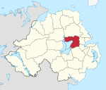
Geografie Traditionelle Grafschaft County Antrim Fläche 577 km² Verwaltungssitz Antrim ISO 3166-2 GB-ANT Demografie Bevölkerung 53.200 (2008) Dichte 92 Ew./km² Konfessionen Protestanten: 56,7 %
Katholiken: 38,6 %Homepage
www.antrim.gov.ukAntrim (irisch: Aontroim) ist einer der 26 nordirischen Districts. Der District, dessen Gebiet in der traditionellen Grafschaft Antrim liegt, wurde 1973 eingerichtet und besitzt seit 1977 den Status eines Borough. Er umfasst das Nord- und Ostufer von Lough Neagh. Bedeutende Orte im Borough sind Antrim, Toomebridge, Crumlin, Randalstown, Parkgate und Templepatrick. Der Flughafen Belfast liegt ebenfalls im Borough.
Inhaltsverzeichnis
Antrim Borough Council
Die Wahl zum Antrim Borough Council am 11. Mai 2011 hatte folgendes Ergebnis:[1]
Partei Ergebnis 2011 Veränderung zu 2006 Sitze Stimmen Sitze Stimmen Democratic Unionist Party (DUP) 5 30,6 % 0 -0,2 % Ulster Unionist Party (UUP) 5 20,8 % 0 -3,0 % Sinn Féin 4 17,2 % 0 2,4 % Social Democratic and Labour Party (SDLP) 3 16,5 % 0 -4,1 % Alliance Party 2 11,3 % 0 4,4 % Traditional Unionist Voice 0 2,1 % 0 2,1 % Sonstige 0 0,6 % 0 0,0 % Siehe auch
Einzelnachweise
- ↑ Wahlergebnis bei BBC News (Abgerufen am 26. Juli 2011)
Weblinks

Antrim | Ards | Armagh | Ballymena | Ballymoney | Banbridge | Belfast | Carrickfergus | Castlereagh | Coleraine | Cookstown | Craigavon | Derry | Down | Dungannon and South Tyrone | Fermanagh | Larne | Limavady | Lisburn | Magherafelt | Moyle | Newry and Mourne | Newtownabbey | North Down | Omagh | Strabane
Wikimedia Foundation.
Schlagen Sie auch in anderen Wörterbüchern nach:
Antrim Borough — Admin ASC 2 Code Orig. name Antrim Borough Country and Admin Code GB.NIR.Q6 GB … World countries Adminstrative division ASC I-II
Antrim Borough Council — NI district district name = Antrim Borough alt name = Comhairle Baile Aontroma district area rank = 11th district area = 577 district HQ = Antrim district iso = GB ANT district ons = 95T protestant pc = 56.7% catholic pc = 38.6% web address =… … Wikipedia
Antrim Borough (Parliament of Ireland constituency) — Parliament of Ireland former constituency infobox Name = Antrim Borough Type = Borough Year = 1666 Post Union = AbolishedAntrim Borough was a two member borough constituency used to elect members of the Parliament of Ireland.Boundaries and… … Wikipedia
Antrim Borough (Northern Ireland Parliament constituency) — Northern Ireland Parliament constituency infobox Name = Antrim Type = County Start = 1929 End = 1973 EM = First past the postAntrim, sometimes known as Antrim Borough to distinguish it from the former constituency of the same name, was a single… … Wikipedia
List of Areas of Special Scientific Interest in Antrim Borough — NOTOC This is a list of the Areas of Special Scientific Interest (ASSIs) in the Antrim Borough area in Northern Ireland, United Kingdom.In Northern Ireland the body responsible for designating ASSIs is the Environment and Heritage Service a… … Wikipedia
Antrim — may refer to: Northern Ireland * County Antrim, one of the counties of Northern Ireland * Antrim, County Antrim, the town * Antrim railway station, serving the town of Antrim * Antrim Borough Council, an administrative division * Antrim GAA, the… … Wikipedia
Antrim Hockey Club — is a hockey club based at Muckamore Cricket Club, Moylena, Nursery Park, Belfast Road, Muckamore. Home fixtures are played on the sand filled artificial surface at the Local Council owned Antrim Forum in Antrim town. The Club was founded in 1894… … Wikipedia
Antrim — bezeichnet: County Antrim, eine historische Grafschaft in Nordirland Antrim (Stadt), eine Stadt in der gleichnamigen Grafschaft Antrim (Borough), einen Distrikt in Nordirland Antrim (New Hampshire), eine Stadt in den USA Antrim County, ein County … Deutsch Wikipedia
Antrim and Newtownabbey District Council — Antrim and Newtonabbey District Council is a proposed Northern Irish local government district. Under the latest decision by the Review of Public Administration the district would be created by merging Antrim Borough Council and Newtownabbey… … Wikipedia
Antrim, County Antrim — Infobox UK place official name= Antrim irish name= Aontroim map type= Northern Ireland latitude= 54.7173 longitude= 6.2055 population= 20,001 (2001 Census) irish grid reference=J1588 unitary northern ireland= Antrim Borough country= Northern… … Wikipedia
Antrim (Borough)


18+
© Academic, 2000-2024
- Kontaktieren Sie uns: Unterstützung, Werbung
Wörterbücher Export, schritte mit PHP, Joomla, Drupal, WordPress, MODx.