- Cabucgayan
-
Municipality of Cabucgayan Lage von Cabucgayan in der Provinz Biliran 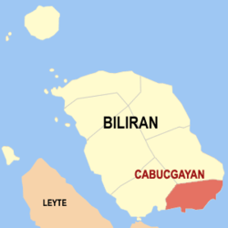
Basisdaten Bezirk: Eastern Visayas Provinz: Biliran Barangays: 13 Distrikt: 1. Distrikt von Biliran PSGC: 087803000 Einkommensklasse: unbekannt (1-6) Haushalte: 3372 Zensus 1. Mai 2000Einwohnerzahl: 18.799 Zensus 1. August 2007Koordinaten: 11° 28′ N, 124° 34′ O11.466666666667124.56666666667Koordinaten: 11° 28′ N, 124° 34′ O Geographische Lage auf den Philippinen 

Cabucgayan Cabucgayan ist eine philippinische Stadtgemeinde in der Provinz Biliran.
Herkunft des Namens
Der Name leitet sich von einer bukgay genannten Schneckenart ab. In Waray wird um die Pluralform eines Nomens zu bilden die Silbe ka vor, und der Artikel an hinten an die Grundform des Wortes angefügt. Das Wort Kabukgayan bedeutet daher „ein Ort an dem es viele Schnecken gibt”.
Baranggays
Cabucgayan ist politisch unterteilt in 13 Baranggays.
- Balaquid
- Baso
- Bunga
- Caanibongan
- Casiawan
- Esperanza (Pob.)
- Langgao
- Libertad
- Looc
- Magbangon (Pob.)
- Pawikan
- Salawad
- Talibong
Schlagen Sie auch in anderen Wörterbüchern nach:
Cabucgayan — Saltar a navegación, búsqueda Mapa de Bilirán mostrando la ubicación de Cabucgayan Cabucgayan es un municipio de quinta clase en la provincia de Bilirán, Filipinas. Conforme al censo de 2000, tiene una población de 17.691 habitantes di … Wikipedia Español
Cabucgayan — Original name in latin Cabucgayan Name in other language Cabucgayan State code PH Continent/City Asia/Manila longitude 11.47194 latitude 124.575 altitude 9999 Population 2700 Date 2011 07 31 … Cities with a population over 1000 database
Cabucgayan, Biliran — Infobox Philippine municipality infoboxtitle = Municipality of Cabucgayan sealfile = locatormapfile = Ph locator biliran cabucgayan.png caption = Map of Biliran showing the location of Cabucgayan. region = Eastern Visayas province = Biliran… … Wikipedia
Legislative districts of Leyte — Philippines This article is part of the series: Politics and government of the Philippines … Wikipedia
Biliran Island — Infobox Islands name = Biliran Island image caption = NASA Landsat image of Biliran. native name = native name link = locator Location map|Philippines|lat=11.523|long=124.535|width=175 map custom = yes location = South East Asia coordinates=… … Wikipedia
PH-BIL — Lage der Provinz Biliran Biliran ist eine Insel und seit 1992 eine eigenständige Provinz der Philippinen. Die Provinzhauptstadt ist Naval. Vor ihrer politischen Eigenständigkeit gehörte die Insel zur Provinz Leyte. Die Insel liegt in den… … Deutsch Wikipedia
Biliran (volcano) — Biliran Elevation 1,301 m (4,268 ft) Location Location … Wikipedia
Biliran — This article is about the province. For the municipality, see Biliran, Biliran. For the Island see Biliran Island. Infobox Philippine province name = Biliran sealfile = Ph seal biliran.png region = Eastern Visayas (Region VIII) capital = Naval… … Wikipedia
Culaba, Biliran — Map of Biliran showing the location of Culaba Culaba is a 5th class municipality in the province of Biliran, Philippines. According to the 2000 census, it has a population of 11,506 people in 2,193 households. Barangays Culaba is politically… … Wikipedia
Maripipi, Biliran — Map of Biliran showing the location of Maripipi Maripipi is a 5th class municipality in the province of Biliran, Philippines. According to the 2000 census, it has a population of 8,319 people in 1,562 households. Barangays Maripipi is politically … Wikipedia
Cabucgayan


18+
© Academic, 2000-2024
- Kontaktieren Sie uns: Unterstützung, Werbung
Wörterbücher Export, schritte mit PHP, Joomla, Drupal, WordPress, MODx.