- Calatagan
-
Municipality of Calatagan Lage von Calatagan in der Provinz Batangas 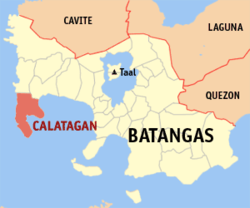
Basisdaten Bezirk: CALABARZON Provinz: Batangas Barangays: 25 Distrikt: 1. Distrikt von Batangas PSGC: 041008000 Einkommensklasse: 3. Einkommensklasse Haushalte: 9201 Zensus 1. Mai 2000Einwohnerzahl: 51.544 Zensus 1. August 2007Koordinaten: 13° 50′ N, 120° 38′ O13.83008120.6395Koordinaten: 13° 50′ N, 120° 38′ O Geographische Lage auf den Philippinen 

Calatagan Calatagan ist eine philippinische Stadtgemeinde in der Provinz Batangas.
Geografie
Die Stadtgemeinde umfasst die Calatagan Halbinsel zwischen dem Südchinesischen Meer und der Balayan Bucht. Die weißen Strände der Halbinsel sind beliebte Erholungsgebiete der Reichen und Berühmten von Manila.
Archäologie
Einer der extrem seltenen Funde von Schriftzeichen aus vorspanischer Zeit auf den Philippinen wurde in Calatagan gemacht. Die Schriftzeichen, im Tagalog Baybayin genannt, wurden auf einer Begräbnisurne aus dem 13. oder 14. Jahrhundert gefunden.
Baranggays
Calatagan ist politisch unterteilt in 25 Baranggays.
- Bagong Silang
- Baha
- Balibago
- Balitoc
- Biga
- Bucal
- Carlosa
- Carretunan
- Encarnacion
- Gulod
- Hukay
- Lucsuhin
- Luya
- Paraiso
- Barangay 1 (Pob.)
- Barangay 2 (Pob.)
- Barangay 3 (Pob.)
- Barangay 4 (Pob.)
- Quilitisan
- Real
- Sambungan
- Santa Ana
- Talibayog
- Talisay
- Tanagan
Städte und Stadtgemeinden in der Provinz BatangasStädte: Batangas City | Lipa City | Tanauan City
Stadtgemeinden: Agoncillo | Alitagtag | Balayan | Balete | Bauan | Calaca | Calatagan | Cuenca | Ibaan | Laurel | Lemery | Lian | Lobo | Mabini | Malvar | Mataas na Kahoy | Nasugbu | Padre Garcia | Rosario | San Jose | San Juan | San Luis | San Nicolas | San Pascual | Santa Teresita | Santo Tomas | Taal | Talisay | Taysan | Tingloy | Tuy
Wikimedia Foundation.
Schlagen Sie auch in anderen Wörterbüchern nach:
Calatagan — 1 Original name in latin Calatagan Name in other language Calalagan, Calatagan State code PH Continent/City Asia/Manila longitude 13.83224 latitude 120.6322 altitude 13 Population 16110 Date 2011 07 31 2 Original name in latin Calatagan Name in… … Cities with a population over 1000 database
Calatagan — 13° 49′ 48″ N 120° 38′ 20″ E / 13.83, 120.639 … Wikipédia en Français
Calatagan, Batangas — Calatagan is a 3rd class municipality in the province of Batangas, Philippines. The town comprises the Calatagan Peninsula between the South China Sea and Balayan Bay. According to the 2000 census, it has a population of 45,068 people in 9,201… … Wikipedia
Calatagan (Batangas) — Calatagan Carte de Batangas avec localisation de Calatagan Calatagan est une municipalité de la province de Batangas. Villes et municipalités de Batangas … Wikipédia en Français
Batangas — Infobox Philippine province name = Batangas sealfile = Ph seal batangas.png region = CALABARZON (Region IV A) capital = Batangas City founded = March 10, 1917 pop2000 = 1,905,348 pop2000rank = 9th largest popden2000 = 602 popden2000rank = 7th… … Wikipedia
Virac, Catanduanes — Virac is a 2nd class municipality in the province of Catanduanes, Philippines. It is the third largest town and the capital municipality of Catanduanes. It has a land area of 188 km². According to the 2000 census, it has a population of 57,067… … Wikipedia
Legislative districts of Batangas — Philippines This article is part of the series: Politics and government of the Philippines … Wikipedia
Miss Earth 2009 — Date November 22, 2009 Presenters Marc Nelson, Borgy Manotoc and Sarah Meier Entertainment Nonoy Libanan Venue Boracay Ecovillage Resort and Convention Center, Boracay, Philippines … Wikipedia
Nasugbu, Batangas — Nasugbu Municipality Map of Batangas showing the location of Nasugbu … Wikipedia
Angel Locsin — Infobox actress name = Angel Locsin image size = 240px caption = Angel Locsin at Avon Presscon birthname = Angelica Locsin Colmenares birthplace = Bulacan, Philippines birthdate = Birth date and age|1985|4|23|mf=y yearsactive = 1999 present… … Wikipedia
Calatagan


18+
© Academic, 2000-2024
- Kontaktieren Sie uns: Unterstützung, Werbung
Wörterbücher Export, schritte mit PHP, Joomla, Drupal, WordPress, MODx.