- Calhoun County (Illinois)
-
Verwaltung US-Bundesstaat: Illinois Verwaltungssitz: Hardin Adresse des
Verwaltungssitzes:Calhoun County Courthouse
P.O. Box 187
Hardin, Il 62047Gründung: 10. Januar 1825 Gebildet aus: Pike County Vorwahl: 001 618 Demographie Einwohner: 5089 (2010) Bevölkerungsdichte: 7,7 Einwohner/km² Geographie Fläche gesamt: 735 km² Wasserfläche: 77 km² Karte 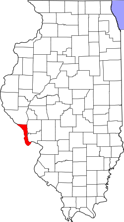
Das Calhoun County[1] ist ein County im US-amerikanischen Bundesstaat Illinois. Bei der Volkszählung im Jahr 2010 hatte das County 5.089 Einwohner und eine Bevölkerungsdichte von 7,7 Einwohnern pro Quadratkilometer. Der Verwaltungssitz (County Seat) ist Hardin.[2]
Inhaltsverzeichnis
Geografie
Das County liegt am westlichen Rand von Illinois und hat eine Fläche von 735 Quadratkilometern, wovon 77 Quadratkilometer Wasserfläche sind. Die Westgrenze des County ist gleichzeitig die Grenze zu Missouri und wird durch den Mississippi gebildet und im Osten durch den Illinois River. Da beide Flüsse im Süden zusammentreffen ist das Calhoun County eigentlich eine Halbinsel. An das Calhoun County grenzen folgende Countys:
Pike County
(Missouri)Pike County Greene County Lincoln County
(Missouri)
Jersey County St. Charles County
(Missouri)Geschichte
 Calhoun
Das Calhoun County wurde am 10. Januar 1825 aus einem Teil des Pike County gebildet. Benannt wurde es nach John C. Calhoun (1782-1850), dem Kriegsminister unter Präsident James Monroe (1817–1825), siebten Vizepräsidenten der USA unter den Präsidenten John Quincy Adams und Andrew Jackson (1825-1832) und Außenminister unter den Präsidenten John Tyler und James K. Polk (1844-1845).
Von 1825 bis 1847 war Gilead der Sitz der County-Verwaltung, danach kurzzeitig Hamburg und noch im gleichen Jahr Hardin.
Demografische Daten
Historische Einwohnerzahlen Census Einwohner ± in % 1830 1090 — 1840 1741 60 % 1850 3231 90 % 1860 5144 60 % 1870 6562 30 % 1880 7467 10 % 1890 7652 2 % 1900 8917 20 % 1910 8610 -3 % 1920 8245 -4 % 1930 8034 -3 % 1940 8207 2 % 1950 6898 -20 % 1960 5933 -10 % 1970 5675 -4 % 1980 5867 3 % 1990 5322 -9 % 2000 5084 -4 % 2010 5089 0,1 % Vor 1900[3] 1900–1990[4] 2010[5] 
Nach der Volkszählung im Jahr 2010 lebten im Calhoun County 5.089 Menschen in 2.043 Haushalten. Die Bevölkerungsdichte betrug 7,7 Einwohner pro Quadratkilometer.
Ethnisch betrachtet setzte sich die Bevölkerung zusammen aus 98,9 Prozent Weißen, 0,1 Prozent Afroamerikanern, 0,2 Prozent amerikanischen Ureinwohnern, 0,2 Prozent Asiaten sowie aus anderen ethnischen Gruppen; 0,4 Prozent stammten von zwei oder mehr Ethnien ab. Unabhängig von der ethnischen Zugehörigkeit waren 0,8 Prozent der Bevölkerung spanischer oder lateinamerikanischer Abstammung.
In den 2.043 Haushalten lebten statistisch je 2,48 Personen.
21,0 Prozent der Bevölkerung waren unter 18 Jahre alt, 59,5 Prozent waren zwischen 18 und 64 und 19,5 Prozent waren 65 Jahre oder älter. 49,6 Prozent der Bevölkerung war weiblich.
Das jährliche Durchschnittseinkommen eines Haushalts lag bei 44.930 USD. Das Pro - Kopf - Einkommen betrug 21.849 USD. 11,3 Prozent der Einwohner lebten unterhalb der Armutsgrenze.[6]
Städte und Gemeinden
- Batchtown
- Brussels
- Hamburg
Einzelnachweise
- ↑ GNIS-ID: 424208. Abgerufen am 22. Februar 2011 (englisch).
- ↑ National Association of Counties Abgerufen am 24. September 2011
- ↑ U.S. Census Bureau - Census of Population and Housing Abgerufen am 15. März 2011
- ↑ Auszug aus Census.gov Abgerufen am 14. Februar 2011
- ↑ United States Census 2010 Abgerufen am 24. September 2011
- ↑ U.S. Census Buero, State & County QuickFacts - Calhoun County Abgerufen am 24. September 2011
Weblinks
-
 Commons: Calhoun County, Illinois – Sammlung von Bildern, Videos und Audiodateien
 - U.S. Census Buero, State & County QuickFacts - Calhoun County
- Yahoo Bildersuche - Calhoun County
- www.city-data.com - Calhoun County
- [http://www.sos.state.il.us/departments/archives/irad/calhoun.html Illinois State Archives - Calhoun County

Liste der Countys in Illinois
Adams | Alexander | Bond | Boone | Brown | Bureau | Calhoun | Carroll | Cass | Champaign | Christian | Clark | Clay | Clinton | Coles | Cook | Crawford | Cumberland | DeKalb | DeWitt | Douglas | DuPage | Edgar | Edwards | Effingham | Fayette | Ford | Franklin | Fulton | Gallatin | Greene | Grundy | Hamilton | Hancock | Hardin | Henderson | Henry | Iroquois | Jackson | Jasper | Jefferson | Jersey | Jo Daviess | Johnson | Kane | Kankakee | Kendall | Knox | LaSalle County | Lake | Lawrence | Lee | Livingston | Logan | Macon | Macoupin | Madison | Marion | Marshall | Mason | Massac | McDonough | McHenry | McLean | Menard | Mercer | Monroe | Montgomery | Morgan | Moultrie | Ogle | Peoria | Perry | Piatt | Pike | Pope | Pulaski | Putnam | Randolph | Richland | Rock Island | Saline | Sangamon | Schuyler | Scott | Shelby | St. Clair | Stark | Stephenson | Tazewell | Union | Vermilion | Wabash | Warren | Washington | Wayne | White | Whiteside | Will | Williamson | Winnebago | Woodford
Wikimedia Foundation.
Schlagen Sie auch in anderen Wörterbüchern nach:
Calhoun County, Illinois — Infobox U.S. County county = Calhoun County state = Illinois seallink = map size = 150 founded = 1825 seat = Hardin largest city = Hardin area total sq mi = 284 area total km2 = 735 area land sq mi = 254 area land km2 = 657 area water sq mi = 30… … Wikipedia
Crater Precinct, Calhoun County, Illinois — Crater Precinct Township Location in Calhoun County … Wikipedia
Belleview Precinct, Calhoun County, Illinois — Infobox Settlement unit pref=Imperial settlement type=Township official name = Belleview Precinct nickname = motto = imagesize = image caption = image mapsize = map caption = Location in Calhoun County subdivision type = Country subdivision name … Wikipedia
Carlin Precinct, Calhoun County, Illinois — Infobox Settlement official name = Carlin Election Precinct settlement type = Township nickname = motto = imagesize = image caption = image imagesize = image caption = image mapsize = map caption = Location in Calhoun County mapsize1 = map… … Wikipedia
Gilead Precinct, Calhoun County, Illinois — Infobox Settlement official name = Gilead Precinct settlement type = Township nickname = motto = imagesize = image caption = image imagesize = image caption = image mapsize = map caption = Location in Calhoun County mapsize1 = map caption1 =… … Wikipedia
Hamburg Precinct, Calhoun County, Illinois — Infobox Settlement official name = Hamburg Precinct settlement type = Township nickname = motto = imagesize = image caption = image imagesize = image caption = image mapsize = map caption = Location in Calhoun County mapsize1 = map caption1 =… … Wikipedia
Hardin Precinct, Calhoun County, Illinois — Infobox Settlement official name = Hardin Precinct settlement type = Township nickname = motto = imagesize = image caption = image imagesize = image caption = image mapsize = map caption = Location in Calhoun County mapsize1 = map caption1 =… … Wikipedia
Point Precinct, Calhoun County, Illinois — Infobox Settlement official name = Point Precinct settlement type = Township nickname = motto = imagesize = image caption = image imagesize = image caption = image mapsize = map caption = Location in Calhoun County mapsize1 = map caption1 =… … Wikipedia
Richwood Precinct, Calhoun County, Illinois — Infobox Settlement official name = Richwood Precinct settlement type = Township nickname = motto = imagesize = image caption = image imagesize = image caption = image mapsize = map caption = Location in Calhoun County mapsize1 = map caption1 =… … Wikipedia
Calhoun County — is the name of several counties in the United States of America, mostly named after Senator John C. Calhoun: Calhoun County, Alabama Calhoun County, Arkansas Calhoun County, Florida Calhoun County, Georgia Calhoun County, Illinois Calhoun County … Wikipedia
Calhoun County (Illinois)


18+
© Academic, 2000-2024
- Kontaktieren Sie uns: Unterstützung, Werbung
Wörterbücher Export, schritte mit PHP, Joomla, Drupal, WordPress, MODx.