California State Route 86S
- California State Route 86S
-
Die California State Route 86S (kurz CA 86S) ist eine State Route im US-Bundesstaat Kalifornien, die in Nord-Süd-Richtung verläuft.
Die State Route beginnt an der California State Route 86 nahe Oasis und endet nach 34 Kilometern in Indio an der Interstate 10.
Verlauf
Nordöstlich des Saltonsees bei Oasis zweigt die California State Route 86S von der CA 86 ab. Die State Route verläuft als mehrspurige Straße in nördlicher Richtung und trifft westlich von Mecca auf die California State Routes 111 und 195. Vor der Stadt Coachella passiert die State Route im Westen den Jacqueline Cochran Regional Airport. Im Osten von Indio endet die Straße wieder an der I-10.
Siehe auch
Weblinks
Wikimedia Foundation.
Schlagen Sie auch in anderen Wörterbüchern nach:
California State Route 86S — Infobox road state=CA type=SR route=86S section=386 maint= length mi=20.840 length round=3 length ref= [ [http://www.dot.ca.gov/hq/structur/strmaint/brlog2.htm January 1, 2006 California Log of Bridges on State Highways] ] direction a=South… … Wikipedia
California State Route 111 — Karte … Deutsch Wikipedia
California State Route 86 — Karte … Deutsch Wikipedia
California State Route 86 — Infobox road state=CA type=SR route=86 section=386 maint=Caltrans length mi=90.67 length ref= [http://www.dot.ca.gov/hq/structur/strmaint/brlog2.htm January 1, 2006 California Log of Bridges on State Highways] ] length round=2 established=1964… … Wikipedia
California State Route 195 — Infobox road state=CA type=SR route=195 section=495 maint=Caltrans length mi=7.42 length round=2 length ref= [ [http://www.dot.ca.gov/hq/structur/strmaint/brlog2.htm January 1, 2006 California Log of Bridges on State Highways] ] direction a=West… … Wikipedia
California State Route 87 — Infobox road state=CA type=SR route=87 alternate name=Guadalupe Parkway section=387 maint=Caltrans length mi=9 length ref= [http://www.dot.ca.gov/hq/structur/strmaint/brlog2.htm January 1, 2006 California Log of Bridges on State Highways] ]… … Wikipedia
State highways in California — Infobox state highway system shields = caption = Standard California state route shields. They are in the shape of a miner s spade to honor the California Gold Rush. state = State Route X (SR X) or Route X interstate = Interstate X (I X) or Route … Wikipedia
California Freeway and Expressway System — The California Freeway and Expressway System is a system of existing or planned freeways and expressways in the U.S. state of California. It is defined by the Streets and Highways Code.List of roads in the system*State Route 1 (part) *State Route … Wikipedia
Liste der State-, U.S.- und Interstate-Highways in Kalifornien — Dies ist eine Aufstellung von State Highways in Kalifornien, USA nach Nummern. Inhaltsverzeichnis 1 State Routes 2 Interstates 2.1 Zubringer und Umgehungen 3 U.S. Highways … Deutsch Wikipedia
Interstate 10 in California — This article is about the section of Interstate 10 in California. For the entire length of the highway, see Interstate 10. Interstate 10 … Wikipedia
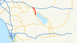
 CA 86 bei Oasis
 I-10 in Indio
