Brownsweg

Brownsweg
5-55.166666666667
Brownsweg
Brownsweg (Suriname)
Brownsweg
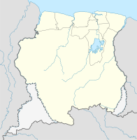
Brownsweg

Brownsweg auf der Karte von Suriname

Basisdaten
Staat Suriname
Distrikt Brokopondo
Einwohner 3871 
Detaildaten
Stadtgliederung 8
Gewässer Brokopondo-Stausee
Zeitzone UTC-3

Brownsweg ist ein Transmigrationsort und Ressort im Distrikt Brokopondo, in der Republik Suriname.

In der ersten Hälfte der 60er Jahre des 20. Jahrhunderts mussten ungefähr 5000 Saramaccaner ihre alten Dörfer und Kultstätten für den Brokopondo-Stausee verlassen. Ein Teil der Betroffenen wurde nach Brownsweg umgesiedelt.

Der Ort ist unterteilt in die Bezirke Nieuw-Ganzee (Sitz des Hoofdkapiteins, dem Dorfoberhaupt von Brownsweg), Maleakondre, Wakibasoe I und II, Birihoedoematoe, Kadjoe, Macambi und Djankakondre. Brownsweg hat 3871 Einwohner.

Brownsweg ist nach dem Weg benannt, der zum gleichnamigen Naturpark Brownsberg führt.


Wikimedia Foundation.

Игры ⚽ Нужен реферат?

Schlagen Sie auch in anderen Wörterbüchern nach:

  • Brownsweg — Saltar a navegación, búsqueda Brownsweg es un suburbio en Surinam en el distrito de Brokopondo; debe su nombre a la carretera que conduce a la montaña Brown y el parque del mismo nombre situado junto al embalse de Brokopondo. Brownsweg se… …   Wikipedia Español

  • Brownsweg — is a town in Suriname …   Wikipedia

  • Brownsweg — Original name in latin Brownsweg Name in other language Bronsweg, Brownsweg State code SR Continent/City America/Paramaribo longitude 5.01667 latitude 55.16667 altitude 49 Population 2696 Date 2012 01 18 …   Cities with a population over 1000 database

  • Brokopondo District — Brokopondo is a district of Suriname. Its capital city is Brokopondo; other towns include Brownsweg and Kwakoegron.The district has a population of 8,340, and an area of 7,364 square kilometres.Brokopondo district is the site of a large reservoir …   Wikipedia

  • Brokopondo — Saltar a navegación, búsqueda Brokopondo Distrito de Surinam Capital …   Wikipedia Español

  • List of cities and towns in Suriname — This is a list of cities and towns in Suriname:*Acaribo *Abenaston *Albina *Alliance *Anapaike *Apetina *Apoera *Aurora *Batavia *Benzdorp *Bitagron *Boskamp *Botopasi *Brokopondo *Brownsweg *Corneliskondre *Cottica *Djumu *Friendship *Goddo… …   Wikipedia

  • Districts of Suriname — Suriname This article is part of the series: Politics and government of Suriname Constitution President …   Wikipedia

  • Commewijne District — Map of Suriname showing Commewijne district Commewijne is a district of Suriname, located on the right bank of the Suriname River. Commewijne s capital city is Nieuw Amsterdam. Alliance is another major town. The district has a population of… …   Wikipedia

  • Coronie District — Map of Suriname showing Coronie district Coronie is a district of Suriname, situated on the coast. Coronie s capital city is Totness, with other towns including Corneliskondre, Friendship, Jenny. The district border the Atlantic Ocean to the… …   Wikipedia

  • Marowijne District — Map of Suriname showing Marowijne district Marowijne is a district of Suriname, located on the north east coast. Marowijne s capital city is Albina, with other towns including Moengo and Wanhatti. The district borders the Atlantic Ocean to the… …   Wikipedia

Share the article and excerpts

Direct link
Do a right-click on the link above
and select “Copy Link”