Kootenay Lake

Kootenay Lake
Kootenay Lake
Corra Linn Dam
KootenayLakeFreeFerry.jpg
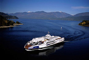
Lage: British Columbia (Kanada)
Zuflüsse: Kootenay River, Duncan River
Abflüsse: Kootenay River
Größere Städte am Ufer: Nelson
Kootenay Lake (British Columbia)
Kootenay Lake
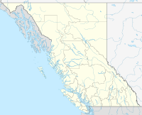
Koordinaten 49° 40′ 0″ N, 116° 49′ 59″ W49.666666666667-116.83305555556Koordinaten: 49° 40′ 0″ N, 116° 49′ 59″ W
Daten zum Bauwerk
Bauzeit: 1930-1932
Kraftwerksleistung: 49 MW
Betreiber: West Kootenay Power and Light (FortisBC)
Daten zum Stausee
Höhe des Stauziels: 532 m
Wasseroberfläche bei Vollstau: 407 km²
Lage des Kootenay Lake

Kootenay Lake ist ein 407 km² großer Stausee am Kootenay River in der kanadischen Provinz British Columbia.[1] Der Stausee gehört zum Flusssystem des Columbia River.

Der Kootenay River wird 30 km vor seiner Mündung in den Columbia River durch den 1930-1932 erbauten Corra Linn Dam zum Kootenay Lake aufgestaut.[2] Der aus Beton bestehende Staudamm besitzt 14 Schütze. Der Stausee entstand erst Ende 1938. Das Wasserkraftwerk hat 3 Generatoren mit einer Leistung von 49 MW und nutzt ein Gefälle von 16 m.[3]

Einzelnachweise

  1. Natural Resources Canada - The Atlas of Canada - Lakes
  2. Balance of Power - Corra Linn Dam
  3. Fortis BC

Wikimedia Foundation.

Игры ⚽ Нужно решить контрольную?

Schlagen Sie auch in anderen Wörterbüchern nach:

  • Kootenay Lake — Infobox lake lake name = Kootenay Lake image lake = KootenayLakeFreeFerry.jpg caption lake = free ferry image bathymetry = caption bathymetry = location = Kootenay region, British Columbia coords = coord|49|40|N|116|50|W|region:CA BC… …   Wikipedia

  • Kootenay Lake Provincial Park — is a provincial park in British Columbia, Canada. It encompasses five widely dispersed parks around Kootenay Lake: Kootenay Lake Provincial Park (Davis Creek site), Kootenay Lake Provincial Park (Lost Ledge sites), Kootenay Lake Provincial Park… …   Wikipedia

  • Kootenay Lake Crossing — was a powerline crossing of Kootenay Lake, British Columbia, Canada. The idea was to move electricity from the Hydro dam on the Kootenay Riverat Brilliant to the Cominco Sullivan Mine at Kimberley. The most direct route was across Kootenay Lake.… …   Wikipedia

  • Kootenay Lake — Koo′tenay Lake′ n. geg a lake in W Canada, in S British Columbia. 64 mi. (103 km) long …   From formal English to slang

  • Kootenay Lake — a lake in W Canada, in S British Columbia. 64 mi. (103 km) long. * * * …   Universalium

  • Kootenay Lake — a lake in W Canada, in S British Columbia. 64 mi. (103 km) long …   Useful english dictionary

  • School District 8 Kootenay Lake — British Columbia Region Kootenays Board office location Nelson Communities served Nelson, Creston, Kaslo, South Slocan, Yahk, Canyon Number of schools 28 Budget: CAD$ (millions) …   Wikipedia

  • Kootenay River — Kootenai Einzugsgebiet des Flusses Daten …   Deutsch Wikipedia

  • Kootenay — (predominant spelling in Canada), Kootenai (predominant spelling in the United States), is alternately spelled Kootanae or Kutenai. The name comes from the name of the Ktunaxa (Kootenai/Kutenai), a Native American/First Nations people in British… …   Wikipedia

  • Kootenay — Kootenay1 [ko͞ot′ n ā΄] n. [see KOOTENAY2] alt. sp. of KUTENAI Kootenay2 [ko͞ot′ n ā΄] [< a native name < ?] 1. river flowing from SE British Columbia through Mont. & Ida. into Kootenay Lake, thence into the Columbia River: 407 mi (655 km) …   English World dictionary

Share the article and excerpts

Direct link
Do a right-click on the link above
and select “Copy Link”