- Dorah-Pass
-
Dorah-Pass 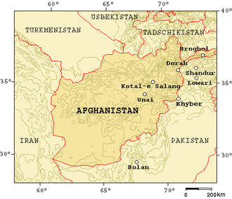
Gebirgspässe in Afghanistan und Pakistan
Passhöhe 4.300 m Ausbau Trekkingpass Gebirge Karakorum Karte 

Koordinaten 36° 6′ 55″ N, 71° 13′ 50″ O36.11520571.2306314300Koordinaten: 36° 6′ 55″ N, 71° 13′ 50″ O Der 4300 Meter hohe Dorah bzw. Dorahpass verbindet den Distrikt Zibak mit Chitral in Pakistan und überwindet den Hindu Kush.
Dieser Pass hatte große Bedeutung während der sowjetischen Invasion, da es ihnen nicht gelang den Waffentransport und die Bewegungen der Mudschahedin zu kontrollieren und zu stoppen. Der Pass war auch ein Fluchtweg nach Chitral.
Der Dorah-Pass war in den letzten 30 Jahren von großer wirtschaftlicher Bedeutung für die Region, da hierüber Edelsteine wie Smaragde und Lapislazuli sowie Lebensmittel und Vieh transportiert werden konnte.
Der Chitral-Distrikt ist nur über vier Gebirgspässe oder von Afghanistan aus über das Kunartal erreichbar. Die anderen Pässe sind der Lowari-Pass, der Broghol-Pass und der Shandur-Pass, der nach Gilgit in Pakistan führt. Im Frühjahr 2010 soll der 8,6 Kilometer lange Lowari-Tunnel fertiggestellt sein, der eine wintersichere Verbindung herstellen wird.
Weblink
Kategorien:- Pass in Afghanistan
- Gebirgspass


Wikimedia Foundation.