- Gaua
-
Gaua Mount Garat vom Lake Letas aufgenommen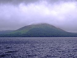
Gewässer Korallenmeer Inselgruppe Banks-Inseln Geographische Lage 14° 16′ S, 167° 31′ O-14.265277777778167.51944444444797Koordinaten: 14° 16′ S, 167° 31′ O 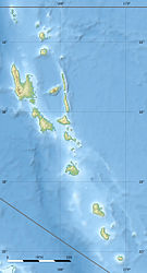

Länge 21 km Breite 20 km Fläche 328,2 km² Höchste Erhebung Mount Garat
797 mEinwohner 2.491 (2009)
7,6 Einw./km²Hauptort Jolap Karte von Gaua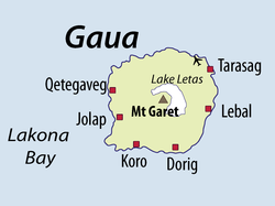
Gaua (früher Santa Maria) ist eine Vulkaninsel, die zum Archipel der Banks-Inseln des pazifischen Inselstaates Vanuatu gehört. Sie liegt in der Nähe der Santa-Maria-Störungszone. Die Insel hat einen Durchmesser von 20 km und eine Fläche von 328,2 km²[1]; der 797 Meter hohe Schildvulkan zählt zu den aktivsten Vulkanen des Archipels.
Am Gipfel des Vulkans befindet sich eine 6 mal 9 Kilometer große Caldera, die 700 Meter tief ist und in der sich ein Kratersee namens Lake Letas gebildet hat. Der größte und aktivste der Intra-Caldera-Vulkane in diesem See ist der Mount Garat. Er liegt im südwestlichen Teil des Sees am Ufer und reicht ein Stück in ihn hinein.
Seit Ende 2009 mehren sich die Anzeichen für einen größeren Ausbruch auf Gaua. Zeitweise wurden 3000 Inselbewohner evakuiert. Kleinere Eruptionen förderten Aschewolken, die bis zu 3 km Höhe aufstiegen. Dabei wurden auch strombolianische Explosionen beobachtet.[2]
Weblinks
Gaua im Global Volcanism Program der Smithsonian Institution (englisch)
Einzelnachweise
- ↑ UNEP Islands
- ↑ Gaua Vulkan auf Vanuatu, Aufruf am 4. Juni 2010
 „Strombolianische Eruption“
Vétaounde | Uréparapara | Rowa-Inseln | Mota Lava | Ra | Vanua Lava | Ravenga | Mota | Kwakéa | Niwula | Gaua | Mérig | Mere Lava
Wikimedia Foundation.
Schlagen Sie auch in anderen Wörterbüchern nach:
Gaua — (also known as Santa Maria Island) (coordinates: coord|14.3|S|167.5|E) is the largest of the Banks Islands in Torba Province of northern Vanuatu. It covers 342 km². Physical geographyIt has rugged terrain, reaching up to Mount Gharat (797 m), the … Wikipedia
Gaua — Pour l’article homophone, voir Goa (homonymie). Gaua Santa Maria Island (en) … Wikipédia en Français
Gaua Airport — IATA: ZGU – ICAO: NVSQ … Wikipedia
gaucherie — gau·che·rie || gəʊʃərɪ n. lack of tact; crudeness; awkwardness; lack of social grace … English contemporary dictionary
gaucheries — gau·che·rie || gəʊʃərɪ n. lack of tact; crudeness; awkwardness; lack of social grace … English contemporary dictionary
gauches — Gau·cho || gaÊŠtʃəʊ n. South American cowboy … English contemporary dictionary
gaucho — Gau·cho || gaÊŠtʃəʊ n. South American cowboy … English contemporary dictionary
Islas Banks — (Banks Islands Îles Banks) Mapa de las islas Banks Localización geográfica / administrati … Wikipedia Español
Îles Banks — Pour les articles homonymes, voir Banks. Îles Banks Banks Islands (en) … Wikipédia en Français
Banks Islands — The Banks Islands (or Îles Banks) are a group of islands in northern Vanuatu. Together with the Torres Islands to the northwest, they make up the northernmost province of Torba. The group lies about 40 km north of Maewo, and includes Gaua and… … Wikipedia
Gaua


18+
© Academic, 2000-2024
- Kontaktieren Sie uns: Unterstützung, Werbung
Wörterbücher Export, schritte mit PHP, Joomla, Drupal, WordPress, MODx.